Click on an item on the map to view information about it
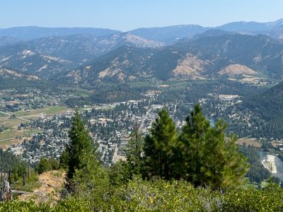
beExploring · Trip Reports · Washington · Leavenworth
Colchuck Lake
A demanding hike to one of the most stunning alpine lakes in Washington, where glacial blue water meets the granite faces of Colchuck and Dragontail Peaks.
Plan This Trip
At a Glance
straighten
Distance
8.2 miles, roundtrip
trending_up
Elevation Gain
2,360 ft
landscape
High Point
5,614 ft
backpack
Activity
Hike
Best For
Northwest Forest PassMountain ViewsAlpine LakeGlaciersPhoto Highlights · June 2026
Jump to Trip Report →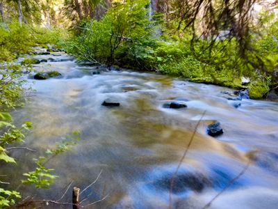


Plan This Trip
Why Go
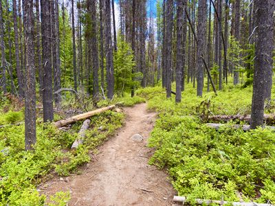
The hike to Colchuck Lake begins at the Stuart Lake Trailhead, sharing the first mile with the Stuart Lake Trail. This opening stretch is relatively gentle, following Mountaineer Creek through forest with scenic wooden bridge crossings over the creek. After roughly a mile, you'll reach the junction with the Colchuck Lake Trail, where you bear left and the character of the hike changes noticeably.
From the junction, the trail steepens and climbs steadily through forest before opening up into a traverse across a rocky scree field. The footing requires attention here, but the effort is rewarded with improving views of the valley below. As you approach the lake, the trail shifts to a series of switchbacks on a rocky, root-covered surface that demands a bit of patience but signals you're nearly there.
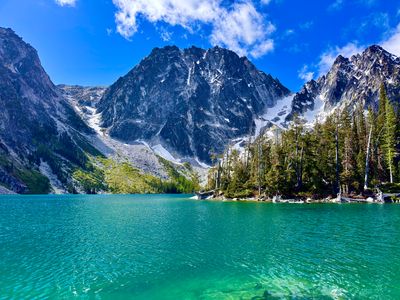
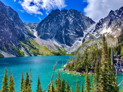
Colchuck Lake comes into view suddenly and the sight is hard to overstate. The water is a vivid glacial blue, flanked by the granite walls of Colchuck and Dragontail Peaks, with lingering snowfields reflecting in the surface well into summer. The shoreline offers plenty of spots to take a break and soak it in.
For those looking to continue, the trail follows the lakeshore and then ascends steeply toward Aasgard Pass. That section transitions from trail to scramble and is a different outing entirely, but Colchuck Lake itself is a complete and rewarding destination on its own.
From the junction, the trail steepens and climbs steadily through forest before opening up into a traverse across a rocky scree field. The footing requires attention here, but the effort is rewarded with improving views of the valley below. As you approach the lake, the trail shifts to a series of switchbacks on a rocky, root-covered surface that demands a bit of patience but signals you're nearly there.
Colchuck Lake comes into view suddenly and the sight is hard to overstate. The water is a vivid glacial blue, flanked by the granite walls of Colchuck and Dragontail Peaks, with lingering snowfields reflecting in the surface well into summer. The shoreline offers plenty of spots to take a break and soak it in.
For those looking to continue, the trail follows the lakeshore and then ascends steeply toward Aasgard Pass. That section transitions from trail to scramble and is a different outing entirely, but Colchuck Lake itself is a complete and rewarding destination on its own.
ac_unit
Trail Snow Coverage
Colchuck Lake
verified Moderate confidence
You are here
Snow-covered
Winter through Late May
Partially snow-covered
Late May to Mid June
Usually snow-free
Mid June through fall
Snow timing varies by year, but upper sections usually hold snow after lower trail sections melt out.
Placeholder in dev for ad
Plan This Trip
Route & Map
Plan This Trip
Getting There
directions_car
Directions
From Leavenworth, follow Icicle Road for 8.5 miles. Turn left onto Eight Mile Forest Service 7601 Rd/NF-7600. In .2 miles, take a slight right onto Eight Mile Forest Service 7601 Rd/NF-7601and continue for 3.6 miles to the Stuart Lake Trailhead.
local_parking
Parking
There is a large parking lot at the Stuart Lake Trailhead, and a Northwest Forest Pass is required. There are a number of spots reserved for overnight permit holders, pay attention to signage. If no parking is available at the trailhead, parking is permissible along the road, again, pay attention to signage to determine which side of the road to park on.
edit_note
Field Notes · Personal Trip Report
Midweek trek to beat the crowds
A later start for this midweek June hike still resulted in a beautiful trip up to Colchuck Lake, with creek crossings, scree fields and an occasional wildflower.
calendar_today June 5, 2026
straighten 8.6 miles, roundtrip · 2,398 ft gain
chat 0 comments
I had planned on waking up at 5am for an early start, unsure of how crowded the hike would be. After having to wake up at 2am to let my sick puppy out for a potty break, sleep eluded me for a while before finally falling asleep again. I reset my alarm to 6am, and upon hearing the alarm, I immediately began questioning my decision to go on the hike today. After going through the reasons for why I should postpone it, I realized I would regret it, and hauled myself out of bed and began the drive to Leavenworth.
I had packed everything in the car the night before, including coffee, but decided I needed a legit cup of hot coffee and stopped by the coffee cabin in Manson. Caffeinated up, it was a pleasant drive up to Leavenworth, although the road up to Stuart Lake trailhead was rougher than I recall - it's not too bad, but definitely quite a bit of washboard.
Arriving at the parking lot around 8am, I was able to find a parking spot, however there were only a couple left outside of the spots reserved for permit holders. There were a handful of groups in the parking lot getting ready to hike, a mix of both day hikers and overnighters. I signed in at the trailhead and began my hike up, anxious to get going.
The trail loosely follows Mountaineer Creek, and the noise from the creek was a pleasant addition to the hike. For the most part you only have occasional views of the creek, and coming upon a section of the trail that was just above the creek, I went down to the bank to snap a quick photo.
Mountaineer Creek
Once back on the trail, I moved aside to let a group of trail runners go by, and I would continue to run into them on the way up as they seemed to be taking quick breaks every mile or so. However, by the time I reached the lake they were no longer in sight. I passed a small number of hikers on the way up, and there were a couple of groups coming down, but otherwise it was fairly quiet considering how popular the trail is.
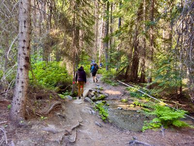
Group going up
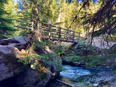
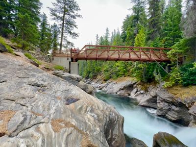
I came to the first wooden bridge crossing Mountaineer Creek and snapped a picture. While not as impressive as the second bridge, it's still quite scenic. From here the trail began to ascend more rapidly. It was still moderate at this point, with an occasional switchback, but certainly steeper than the first mile.
First wooden bridge
There were a number of chipmunks and birds along that trail that seemed very interested in me. I suspect they are used to getting food, as they seemed to follow me a bit before giving up. Soon I reached the junction with the Colchuck Trail. Proceeding up the trail, I popped out of the woods and reached the second bridge across Mountaineer Creek, with views of the valley. Once across the bridge, I followed the trail through boulders and a scree field - a cool section of the trail.
Second bridge across Mountaineer Creek
Surprisingly, there weren't many wildflowers along the trail -I saw a patch of bluebells shortly after the second bridge, but don't recall seeing any others during the hike. As I made it above 5,000 ft elevation, the views started to open up. I climbed up on a rock outcropping to take in the views of the valley.
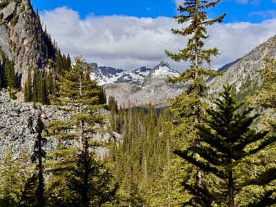
Views of the valley
The trail at this point becomes quite a bit steeper, with lots of rocks and roots. It's not too bad, but my pace certainly slowed down as I progressed up towards the lake. I knew I was getting close, but unsure exactly how long I had until it flattened out a bit and I recognized that I was about to see the lake. Even though I have done the hike before, it's been quite awhile, and the views did not disappoint.
First view of Colchuck Lake
I continued along the trail until I reached a granite section overlooking the lake, and made my way down to find a place to sit. I could see people spread out along the water's edge, but was able to find a rock to sit on. Just out of view from my rock, two women were blowing up inflatable rafts and I could hear their shrieks as they hit the cold water. It's a beautiful alpine lake, but certainly not a place you can expect solitude!
Colchuck Lake and Dragontail Peak
I enjoyed the views, ate and hydrated and then headed back up to the trail for the hike out. A short while later I mistakenly took a right down a side trail, and noticed a large rock along the lake and decided to check that out before heading down. I hopped up onto the rock, took some photos and soaked in the views one last time.
Final views of the lake
I scrambled back up to the trail, and then started the hike down to the car. I felt pretty good, the hike up hadn't worn me out too much, and I made quick work of the steep section of the trail, pulling over periodically to let hikers coming up go by.
Heading down
Upon reaching the car, the lot was now filled. However, there were only a handful of cars parked along the road. Not bad for a weekday in June I guess. It was a great day to get out, with beautiful weather and views, and not too many people along the way!
Comments
on this trip report · Jun 2026
More From The Area
Nearby Trip Reports
beExploring / Leavenworth
Comments
0No comments yet. Be the first to share your thoughts!