Click on an item on the map to view information about it
beExploring · Trip Reports · Utah · Big Cottonwood Canyon
Lake Blanche
Lake Blanche is a popular hiking destination located in the Wasatch Mountains of Utah. The trailhead is easily accessible from Salt Lake City, and the hike itself is moderate to difficult, with a significant amount of…
Plan This Trip
At a Glance
straighten
Distance
7 miles, roundtrip
trending_up
Elevation Gain
2,700 ft
landscape
High Point
8,980 ft
backpack
Activity
Hike
Photo Highlights · June 2022
Jump to Trip Report →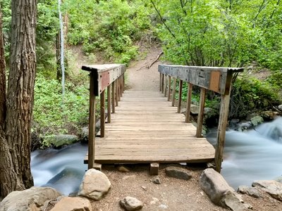
Plan This Trip
Why Go
Lake Blanche is a popular hiking destination located in the Wasatch Mountains of Utah. The trailhead is easily accessible from Salt Lake City, and the hike itself is moderate to difficult, with a significant amount of elevation gain over a couple of miles. The trail starts off paralleling a stream and continues up the mountain through beautiful forests and meadows, offering stunning views of the surrounding mountains and wildlife. After a steady climb, hikers are rewarded with stunning views of Lake Blanche and the surrounding peaks, with options to view or hike down to the nearby Lake Florence and Lake Lillian. The crystal clear waters of the lake provide the perfect opportunity to take a break and enjoy the scenery before heading back down the trail. Overall, the Lake Blanche hike is a must-do for outdoor enthusiasts visiting Utah.
Placeholder in dev for ad
Plan This Trip
Route & Map
Plan This Trip
Getting There
directions_car
Directions
Drive East on UT-190 E/6200 S/Big Cottonwood Rd. for 6 miles, and the parking lot will be on your right hand side.
local_parking
Parking
There is a small parking lot available that typically fills up quickly with cars during popular hiking times. Spillover parking is available along the shoulder of the road. No parking passes are needed.
edit_note
Field Notes · Personal Trip Report
Father's Day Detour
I squeezed in a pre-dawn hike before dropping my parents at the airport, racing the sunrise up to the lake and back in time for breakfast.
calendar_today June 19, 2022
straighten 7.8 miles, roundtrip · 2,850 ft gain
chat 0 comments
I was originally planning on spending father’s day with my wife and son exploring Salt Lake City, as I had to drop my parents off at the airport for their flight. However, after I found out I was dropping them off at 6:30am, I decided to squeeze in a quick hike near Salt Lake and let my wife and son sleep in. After a quick google search, I landed on Lake Blanche.
The hike was relatively close to the airport, wasn’t too long and at a moderate elevation - I had just flown in and needed some time to adjust before heading up really high, and I was also unsure about the snowpack and didn’t feel like scrambling through snowfields.
I arrived at the trailhead a little before 7am and was surprised to see cars already parked on the side of the road. Assuming the trailhead parking was full, I pulled my car off to the side of the road and upon walking into the trailhead parking lot, I noticed a couple of empty parking spots.
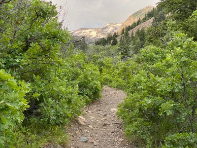
I walked along the paved path for a quarter of a mile, enjoying the sound of the rushing river next to the trail, before seeing the sign indicating the start of the Lake Blanche hike. The trail began an immediate ascent, and would continue to rise for the rest of the hike. It’s not a particularly steep trail, however it relentlessly progresses up - how else can you cover over 2,700ft of vertical gain in under 3 miles?
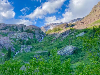
The trail had a small bridge to cross over the Bill B South Fork, and continued up on the East side of the river. I was expecting to encounter some other groups as I made my way up the trail, however I was pleasantly surprised and had the trail to myself, enjoying the sounds of the birds and rushing river. Fairly quickly, I was able to catch my first glimpses of the snow capped peaks up above.
Mill B South Fork bridge on Lake Blanche Trail
First glimpse of snow capped peaks from the Lake Blanche Trail
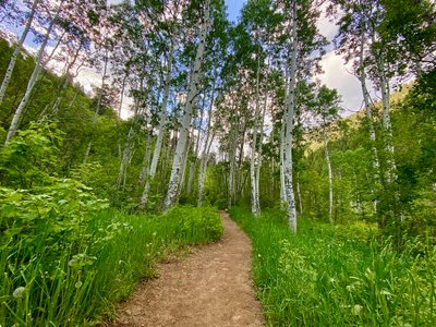
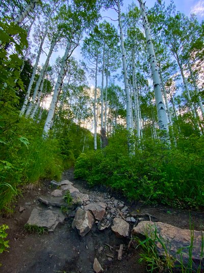
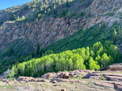
I kept a steady pace up the trail, and passed numerous patches of wild flowers, before finally coming into my first stand of aspen trees. While aspen stands exist in Washington State, I don't see them where I hike, and I always look forward to encountering them when I’m in the Wasatch. There’s something about hiking through (or better yet, skiing through) an aspen stand.
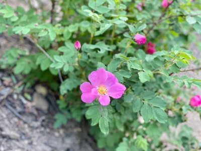
Wild flowers along the Lake Blanche Trail
Aspen stand on the Lake Blanche Trail
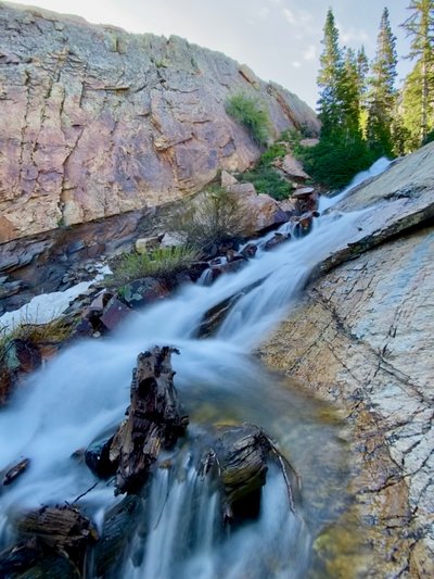
I continued ascending the trail and saw a large rambling waterfall coming down in the distance. Judging by its location, it looked like it was coming out of the area I was heading to. I quickly consulted a map to see if the trail would take me closer, but realized the trail wrapped around farther away and the waterfall was coming out of Lake Lillian, and not something I would be able to easily see from Lake Blanche.
Waterfall coming out of Lake Lillian
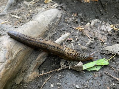
Along the way I saw a slug, which is not something I was expecting to see in the Wasatch. I see them all the time hiking in the Cascades, but I wrongly assumed the drier climate in Utah would preclude slugs from living here...
Another aspen stand along the trail
Slug on the Lake Blanche Trail
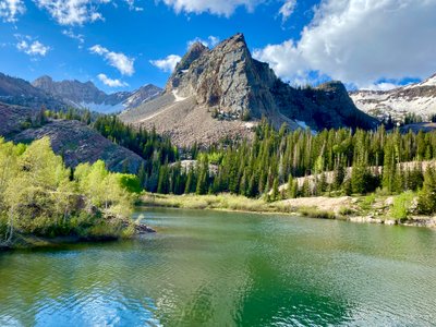
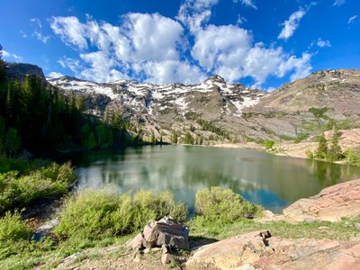
I finally reached Lake Blanche and was rewarded with a great view of the Lake and the surrounding mountains - definitely a scenic view and worth the effort to get up there. I snapped some photos and then made my way over to an old worn out wall on the side of the lake (assuming it was used to raise the lake level for irrigation purposes?).
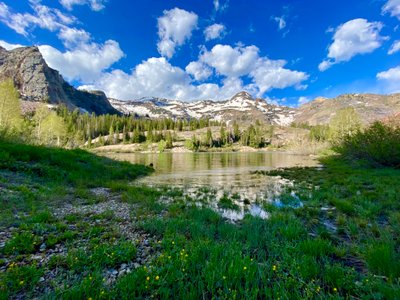
First view of Lake Blanche
Sundial Peak towering over Lake Blanche
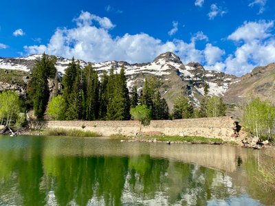
Old wall on Lake Blanche
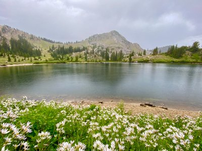
I made my way across the old wall and tried to descend to get a better view of Lake Lillian. I quickly ran into some steep terrain mixed with cliffs, and there was a raging stream coming out of Lake Blanche that prevented me from crossing over, so I backtracked over the wall again and followed a trail towards Lake Lillian. I stopped above the Lake, took some more pictures and had a quick snack and slug of water.
Lake Lillian
I then retraced my steps over the old wall and hiked on a small trail along the southern shore of Lake Blanche. I followed the trail higher above the lake and then descended back towards the Lake, and had to find a suitable spot to cross the South Fork of Mill B Creek.
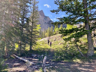
A couple hiking above Lake Blanche
South Fork Mill B flowing into Lake Blanche
I cruised back along the shore and completed my circumnavigation of Lake Blanche. If I had to do it again, I would not bother going around Lake Blanche and would have spent more time hiking around Lake Lillian. It would have been cool to try and find the waterfall flowing out of Lake Lillian. I walked along the rocks to catch a final view of the valley before embarking on my descent.
Aspen grove and rocks
While I had only encountered a couple of people on the hike up, the hike down was a different story. I must have passed at least twenty separate groups - obviously a popular hike, and for good reason. I was glad I had an early start and got some solitude on the hike up. The shoulder of the road was completely filled with cars.
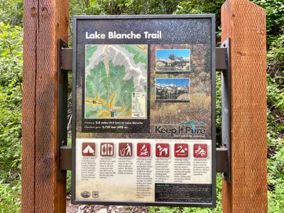
Lake Blanche sign
I didn’t put much thought or planning into this one, but it worked out perfectly and was a great way to kick-off my stay in the Park City area. I highly recommend this hike!
Comments
on this trip report · Jun 2022
More From The Area
Comments
0No comments yet. Be the first to share your thoughts!