Click on an item on the map to view information about it
beExploring · Trip Reports · Italy · Palermo
Monte Gallo
Monte Gallo, in the Riserva Naturale di Capo Gallo, offers a moderate hike within the city of Palermo with fantastic views of the Tyrrhenian Sea and Palermo. The road leading to the start will take you past a semi-des…
Plan This Trip
At a Glance
straighten
Distance
3 miles, round trip
trending_up
Elevation Gain
1,300 ft
landscape
High Point
1,670 ft
backpack
Activity
Hike
Photo Highlights · September 2023
Jump to Trip Report →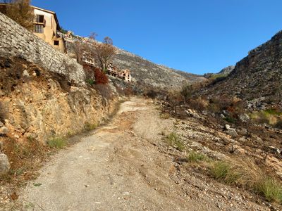
Plan This Trip
Why Go
Monte Gallo, in the Riserva Naturale di Capo Gallo, offers a moderate hike within the city of Palermo with fantastic views of the Tyrrhenian Sea and Palermo. The road leading to the start will take you past a semi-deserted housing development, which combined with the recent fires in the area gives the start of the hike an almost post-apocalyptic feel. The hike follows an old road which switchbacks up the side of Monte Gallo, taking you through a mix of forest and more open areas. Near the top, follow a rock lined trail to reach the Semaforo Borbonico dell'Eremita Isravele, a historical building which is now inhabited by a hermit named Isravele . Past visitors have noted Isravele allowed them to tour the building, and recommend bringing some food to share with him. Enjoy expansive views of the sea before following the trail and road back down, or make your way east for a quarter of a mile through the burned area (no real defined trail) for vistas of Palermo before heading back down.
Placeholder in dev for ad
Plan This Trip
Route & Map
Plan This Trip
Getting There
directions_car
Directions
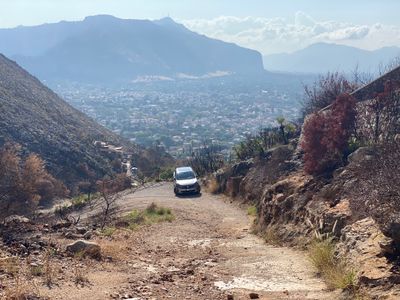
You will take the Via del Semaforo and pass through a gate near the bottom, which is always open. The condition of Via del Semaforo deteriorates as you progress up, and there are some small turnarounds where it is possible to park. I would not advise trying to drive to the end of Via del Semaforo in a low clearance vehicle, and if you are taking a taxi, they will likely want to drop you off at the start of Via del Semaforo, which will add some mileage to the hike.
local_parking
Parking
As mentioned in the directions, the upper sections of Via del Semaforo are rough, and where you park will depend how comfortable you are driving up the road. There is street parking near the start of Via del Semaforo, and while driving up the road there are occasional spots to snugly fit a car to the side of the road. At the top of Via del Semaforo there is a small area capable of holding a couple of cars.
edit_note
Field Notes · Personal Trip Report
Palermo's Secret Peak
I drove cautiously up the crumbling Via del Semaforo, parked by the narrow bridge, and hiked through fire-scarred switchbacks to a clifftop semaphore tower overlooking the Tyrrhenian Sea.
calendar_today September 27, 2023
straighten 3.6 miles, round trip · 1,350 ft gain
chat 0 comments
After a couple of fun days relaxing at the pool and beach, I was ready to stretch my legs and go for a quick hike. Palermo is surrounded by mountains, and I was hoping there would be some close by hikes. After some quick searching online, I landed on Monte Gallo, as it was less than a 15 minute drive from our hotel, and it's one of the mountains I had been eyeing while laying on the beach.
As I drove up Via del Semaforo, I started second guessing myself. The condition of the road was poor, and as I passed through an extremely narrow one lane bridge, I decided I didn't want to risk driving up any further and then being forced to back down the road. Fortunately there was a small spot to pull over just past the bridge, and I wasn't that far from the start of the hike.
Rough section of Via del Semaforo with abandoned buildings
On the left as I hiked up the last part of Via del Semaforo were a number of abandoned homes, which combined with the charred landscape gave it a somewhat eerie feel - I was half expecting a zombie to jump out and start attacking me. After a quick hike, I arrived at a half open gate, which was where I had originally planned to park. It looked like you could open the other half and potentially keep driving up, as the road was in much better shape, but then that wouldn't make much of a hike.
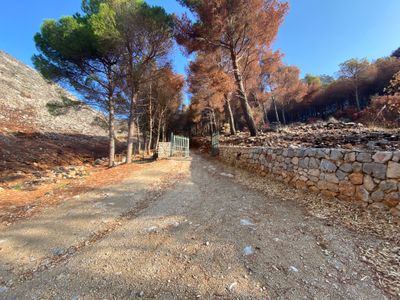
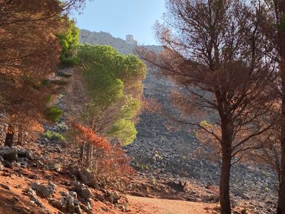
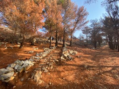
Start of the hike
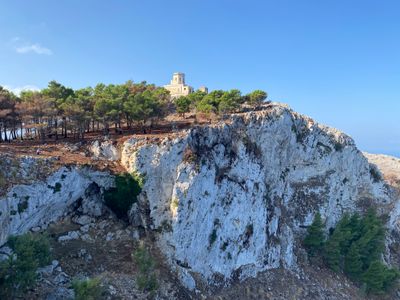
The trail, which is really more of a road, was fairly steep at the start, and I worked up a sweat even though there was a nice breeze and the trees provided shade from the morning sun. A break in the trees provided my first view of Semaforo Borbonico dell'Eremita Isravele perched on top of the mountain.
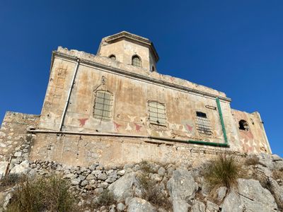
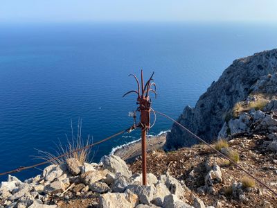
Semaforo Borbonico dell'Eremita Isravele
After a couple more switchbacks, the road departed from the forest and headed southeast across the mountain. There were impressive views across the valley at the semo-deserted housing development. Shortly after entering the forest again, I noticed a stone lined path breaking off from the road and heading up in the general direction of the Semaforo Borbonico.
Trail up to the top
A short hike later, and I was at the Semaforo Borbonico dell'Eremita Isravele. After the hike, I looked up the translation of Semaforo, and learned it means traffic light. I'm still trying to figure out why the building is called a traffic light… I thought maybe Semaforo was another name for a lighthouse , but that doesn't appear to be the case.
Semaforo Borbonico dell'Eremita Isravele
The side of the building had angels or fairies painted on the side, and rounding the corner there was a large mosaic on the side of the wall, as well as some other whimsical artwork. As I was admiring the structure, I heard some barks and then suddenly two cute puppies appeared. There was no sign of the hermit Isravele, and while the puppies seemed friendly enough, I opted to head down a short way to get a better view of the sea.
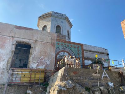
Semaforo Borbonico dell'Eremita Isravele
I walked down to a trail to the edge of a large cliff and stared over the abyss towards Capo Gallo over 1,500ft below. Staring out at the Tyrrhenian Sea, I could see a small number of boats cruising through the water. After enjoying the view for a while, I decided to follow the trail as it headed down along the ridge.
Capo Gallo and the Tyrrhenian Sea
I headed down and to the east, and as I was admiring a nice view of the Semaforo Borbonico dell'Eremita Isravele perched on the cliff, a couple of mountain bikers stopped to enjoy views of the Tyrrhenian Sea. They were the only people I would see until after the hike when I was driving down Via del Semaforo and passed by a couple of people walking up the road.
Semaforo Borbonico on Monte Gallo
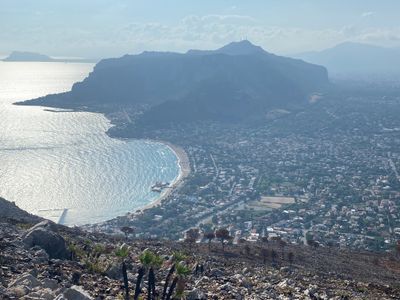
I still hadn't caught a view of Palermo, and decided to head and go over the ridge. I followed the trail until it intersected with the road. When I had looked at the satellite imagery before the hike, it looked like there might be a trail that looped towards Palermo, but I was unable to locate it, possibly due to all the damage caused by the recent fires. The terrain was open and straightforward to make my way over for a view of Palermo. Walking through the charred aftermath of the fire, the ground seemed quite churned up. Not sure if there are wild boars around the area, but it looked like something had come through and rooted through the ground. After cresting the ridge, I hiked down a small ways and was treated to some nice views of Palermo.
Palermo
The view of Palermo was a bit hazy, not sure if that was morning marine layer, smog or something else. After a couple of photos, I retraced my steps back to the road, and then started the descent back to the car. In this direction, I had a constant view of the abandoned housing development across the valley, and now I could see that there were some residences which seemed occupied.
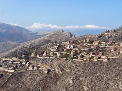
Abandoned housing development
I expected to see the mountain bikers come flying down past me on my way down, as it's hard to imagine another route down given the cliffs on the north and east of Monte Gallo, but that never happened. This is a nice hike, especially how close it is to the Mondello neighborhood in Palermo where we were staying. Definitely recommended if you are looking to get out for a quick and moderately strenuous hike in Palermo!
My rental car parked on the side of Via del Semaforo
Comments
on this trip report · Sep 2023
More From The Area
Comments
0No comments yet. Be the first to share your thoughts!