Click on an item on the map to view information about it
beExploring · Trip Reports · Washington · Twisp
Twisp Pass
A challenging but rewarding full-day hike that climbs from the Twisp River valley to a high alpine pass on the boundary of the Pasayten Wilderness. The 8.6-mile round trip gains 2,400 feet through forest, open meadows…
Plan This Trip
At a Glance
straighten
Distance
8.6 miles, roundtrip
trending_up
Elevation Gain
2,400 ft
landscape
High Point
6,064 ft
backpack
Activity
Hike
Best For
Mountain ViewsWildflowersNorthwest Forest PassRemotePhoto Highlights · October 2025
Jump to Trip Report →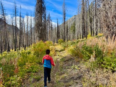

Plan This Trip
Why Go
Twisp Pass Trail offers a spectacular journey into the heart of the North Cascades, winding through lush forests, open meadows, and up to high alpine views near the boundary of the national park. The trail begins with a gentler grade, leading you past beautiful eastern-slope scenery, including aspens and wildflowers in season. A highlight for all hikers comes at about two miles in, where a sturdy log bridge crosses the North Fork of the Twisp River. This point serves as a perfect, picturesque turnaround for those seeking a shorter, more relaxed hike before the main climb, a little under 2,000 feet, to the 6,064-foot pass begins in earnest.
Note, Twisp Pass can also be reached from the West via Highway 20 and the Stiletto Spur Trail. The description here is for the Twisp River Valley approach from the East.
Note, Twisp Pass can also be reached from the West via Highway 20 and the Stiletto Spur Trail. The description here is for the Twisp River Valley approach from the East.
Placeholder in dev for ad
Plan This Trip
Route & Map
Plan This Trip
Getting There
directions_car
Directions
In Twisp, turn left onto W 2nd Ave and continue onto Twisp River Rd for 6.3 miles. Continue straight onto NF-44/Twisp River Rd for 11.2 miles. Take a slight right onto NF-4440 and in 6.5 miles take a right to reach the Gilbert Trailhead. Note the road becomes undriveable shortly after passing the Gilbert Trailhead.
local_parking
Parking
There is a good sized parking lot with a vault toilet at the Gilbert Trailhead, which provides access to the Twisp Pass trail as well as North Creek trail. A northwest forest service pass or daily fee is required. There was no drop box for the daily fee, rather instructions on how to use a website/application to purchase your pass.
edit_note
Field Notes · Personal Trip Report
Log Bridge Shortcut
My son and I bailed on the full climb after Tim's River Fest to hit the iconic North Fork crossing instead—perfect festival-day compromise with imposing mountain walls the whole way up the valley.
calendar_today October 4, 2025
straighten 4.3 miles, roundtrip · 835 ft gain
chat 0 comments
My son and I had made the drive up to Twisp to catch some live music at Tim's Twisp River Fun Fest, and I wanted to get out for a reasonably quick hike as well. Wanting a relatively moderate hike, there weren't too many options. I had recently done part of the Twisp River trail, so that was out, and the first section Twisp Pass trail to the bridge looked to be a perfect fit for the day. After listening to some music, we hopped in the car and made the drive all the way up the Twisp River Valley to the Gilbert Trailhead. This was my first time driving to the end of the valley, and it's quite impressive with imposing mountains on both sides.
There were around 10 cars at the trailhead, definitely more than I expected at the trailhead. We only ran into one group on the trail, so I wouldn't be surprised if folks were out backpacking, enjoying the larches higher up in the mountains. We took a left on the trail (to the right is the North Creek Trail which takes you to the northern side of Gilbert Mountain) and started our hike.
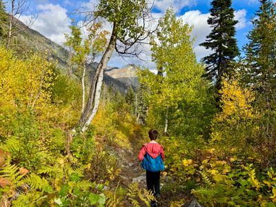
Start of the Twisp Pass Trail
The trail starts out relatively flat. It's about 600 feet up to the bridge, which is where we planned to turn around, with the majority of the incline coming in the later part of this section. It was a nice cool fall day, with scattered clouds high above the mountain tops - my first fall hike of the season. There were some decent colors, with occasional small stands of aspen and various shrubs showing a little color, although there were large sections of dead / burned trees. High above in the upper reaches of the peaks we could see the larches starting to turn.
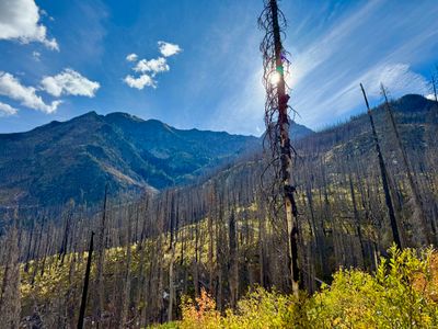
Larches on the top of Crescent Mountain
A little less than a mile in we passed into the Lake Chelan-Sawtooth Wilderness, with a large sign on a tree letting us know. Unlike our Agnes Gorge hike outside Stehekin a couple of months ago, we wouldn't be making it to the North Cascades National Park this time, which begins just past Twisp Pass.
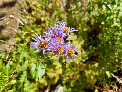
The trail began to ascend a bit more as we progressed, and we took a short break for my son to drink some water and eat a little food. The pace was a little slower with my son in tow, but he did a good job of keeping up while hiking up. We saw a few flowers still in bloom, which I believe are Douglas Aster. There was a lot of fireweed along the trail, but it was all well past bloom.
Douglas Aster along the trail
Farther up the trail we saw a squirrel hanging around on the side of a tree checking us out. He eventually jumped off the tree and onto a log, but kept staring at us… Aside from some other squirrels, no other wildlife was seen during the hike. We did hear some branches breaking in the forest on the way back, sounded like a larger animal, but we weren't able to see anything.
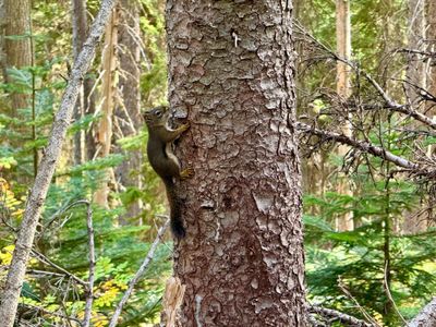
Squirrel on a tree
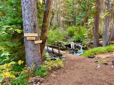
A short while later we reached the junction with the Copper Pass Trail, and saw the bridge to our left. We crossed the bridge. It's a fairly narrow log bridge, but fortunately there is a handrail on the side, as my son was a little apprehensive about crossing it. Apparently, it used to not have the handrail and I imagine could be a treacherous crossing when wet. We went a couple hundred feet up the trail and found some rocks to sit down, hydrate and eat a little food.
Trail junction and bridge
While we were resting, a group of two passed us on their way down. We made our way back across the bridge across the South Fork of the Twisp River, and I headed down to the river to take a photo of a small cascade. There was decent water flow with the recent rains, but I'm sure nothing compared to the spring when all the snow is melting.
South Fork of the Twisp River
The hike back down the trail was uneventful, making good time as it was all slightly downhill or flat. We passed by a cool Aspen tree which had a split in the lower section of its trunk. We started to get a little rain towards the end of the hike, but the cloud eventually passed through and we got a little sunshine as well.
Split aspen
Back at the car, we headed to Tim's place to catch some more live music. It was a nice fall hike, and great one for my son, a little over 4 miles and 800 vertical feet. Looking forward to heading back sometime and making it all the way up to Twisp Pass.
Comments
on this trip report · Oct 2025
More From The Area
Comments
0No comments yet. Be the first to share your thoughts!