Click on an item on the map to view information about it

Twisp River
Twisp,
Washington
overview
LENGTH : 14 miles, one way
ELEVATION GAIN : 2,000 ft.
TYPE : hike
HIGH POINT : 3,705 ft.
The name of the trail, Twisp River Trail, is a little misleading, as the trail spends most of its time along the side of the valley, away from the Twisp River. That being said, it is a scenic route that follows the Twisp River Valley through forests, meadows, and below rugged mountain terrain. Stretching about 7 miles one way, the trail offers a gentle grade that makes it accessible for hikers, horseback riders, and backpackers alike, and is one of the few trails in the area that doesn't require significant elevation gain. Along the way, visitors are treated to views of cascading streams, old-growth trees, burned areas and potentially glimpses of wildlife, including deer and black bears. Because it winds deep into the Twisp River Valley, the trail is a quieter alternative to some of the more heavily traveled North Cascades routes and spring and early summer provide great wildflowers viewing.
The Twisp River trail starts at the Twisp River trailhead, which is also the Twisp River Sno-Park in the winter. The actual sign denoting the trail is found a couple hundreds yards past the Sno-Park along an old forest service road. The trail heads northwest along the side of the valley, and has additional access points at War Creek Bridge, Scatter Creek Trailhead, Slate Creek Trailhead, and South Creek Trailhead, before terminating near the end of the valley below Gilbert Mountain.
Placeholder in dev for ad
Directions
Parking
Trip Reports
August 14, 2025
DOWNLOAD GPXTOTAL MILEAGE : 4.2 miles, roundtrip
ELEVATION GAIN : 370 ft.
HIGH POINT : 2,585 ft.
I was in the Twisp River Valley dropping my son off at a friend's house for an overnight stay and wanted to get a quick hike in. There are some burly hikes in the valley that are on my list, but I didn't have the time or desire, given the high 80's temperature, to slog up the steep mountains in the valley, especially without the payoff of reaching a lake or high point.
I settled on the Twisp River Trail, and made my way to the Twisp River Sno-Park. As expected, there were no cars in the parking lot. There is no signage at the Sno-Park about the Twisp River Trail, but I made my way along an old gravelly road, and after about a quarter mile, I saw a sign attached indicating the start of the trail.
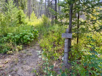
Start of the Twisp River Trail
The trail was a bit overgrown at the start, and appeared to skirt around a large downfallen tree, with a couple of rock cairns there to help find the way. However, after that the trail was in pretty good shape. There were occasional sections that were overgrown with fireweed and some shrubs, but for the most part the trail was in pretty good shape. And less than a mile in, there were some nice views of the Twisp River Valley.
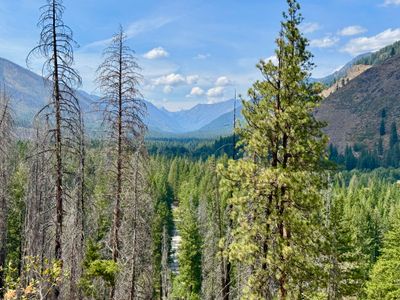
View of Twisp River Valley
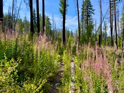
The trail has a small amount of elevation gain in the first two miles, but not enough to dissuade a family hike. There is a bit of shade on the hike, but for the most part you are in the sun, as you pass through open meadows and burnt out forest. I was certainly feeling the heat on my hike, and glad I wasn't on a trail with a ton of elevation gain.
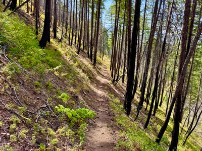
Burnt Out Forest Along the Trail
A little over a mile in, I crossed a small stream which was still running. It was easy to get over, but I imagine in the spring and early summer it might have a lot more flow, and require a little effort to get over without getting wet. There were a couple of other dried up creek beds I passed along the way, but this was the only one with running water this late in the summer.
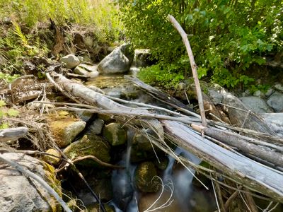
Running Creek
Outside of the fireweed, there weren't really any other wildflowers this late in the season. I wasn't expecting to see lots of wildflowers, but sometimes you can be pleasantly surprised. The trail descended a bit, and now I could see the road below, but still no sight on the Twisp River.
Fireweed Along the Trail
A little over 2 miles into the hike, I turned around and started making my way back. Outside of seeing a deer scamper away in the distance right near the turnaround point, it was an uneventful hike back. The Twisp River Trail is a nice easy hike in an impressive valley, and suitable for families or those looking for a less strenuous hike. And I imagine the wildflowers are pretty spectacular in the spring and early summer.