
Uno Peak
Manson,
Washington
Overview
Uno Peak sits high above Lake Chelan in the remote Lake Chelan-Sawtooth Wilderness, and the trailhead, across from South Navarre Campground, is as far as you can drive uplake on the north shore before the road starts heading down into the Methow Valley. While the trails around Uno Peak are more popular with dirt bikers than hikers, you can combine a couple of different trails for a great loop hike around Uno Peak, with an optional off-trail summit of Uno Peak. During a typical winter, expect snow into early June on the upper parts of Grade Creek Forest Road.
Hike the Summit Trail below South Navaree Creek, descending into the Safety Harbor drainage. At 2.5 miles you will reach a junction with the Safety Harbor Trail, continue following the Summit Trail for a little over two miles, and then proceed west on the Uno Peak trail. Once over the ridge between Ferry Peak and Uno Peak, you can optionally do a non-technical scramble up the northern ridge to the top of Uno Peak, and then hike down the southern ridge back to the trail (if you don't do this, the hike should be about 3,800 feet of elevation gain). Continue along the Uno Peak trail as it descends down and ultimately connects with the Safety Harbor Trail - this section of the Uno Peak Trail has a washout which is easily passable on foot, but prevents dirt bikers from using the trail, which means the trail may be quite overgrown. Also note, there is no bridge across Safety Harbor Creek, and the creek can have quite a bit of water flowing in the early summer, so be prepared to get wet fording the creek. Continue up the Safety Harbor Trail for 1.5 miles, and then take the Summit Trail back to the road.
Directions
Parking
Trip Reports
Even with my early start at 6am, there was surprisingly a car ahead of me driving very slowly along Grade Creek Road. Fortunately, the car pulled over after 5 miles, as it took 1 hour and 45 minutes going at a reasonable speed and would have been much longer going 10 miles per hour. There had been work done on the road to get heavy equipment out for the Pioneer Fire, so the road is in pretty good shape. The last 5 or so miles it was a little rougher, but not too bad. About a half mile from the trailhead, I ran into a large patch of snow. I thought I could drive through it, but after a couple of tries, my car started to slide off the road. There wasn't a steep drop like other parts, but it was a hill and if I went off the road this far out, it wouldn't be good. After about 20 minutes of shoveling, both snow and dirt, I was able to back my car up and park it, very relieved I didn't get stuck out in the middle of nowhere. I walked the half mile to the trailhead, beginning my hike behind schedule and a little worn out from all the digging...
The trail starts out traversing under South Navarre Peak, and I immediately had good views of the summit of Uno Peak. The trail was in good shape, considering I was probably the first person to hike it this year. While there was snow higher up on some of the peaks, the Summit Trail was fortunately snow free. Roughly a half mile in, I came across a spring on the side of the trail, with running water and lots of greenery growing on the hill, certainly much more than I am used to seeing around lake chelan this time of year.
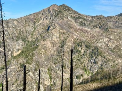
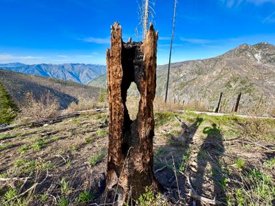
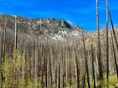
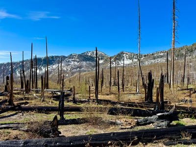
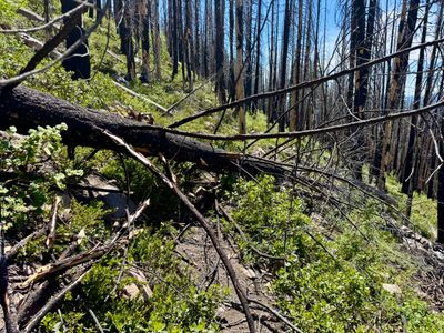
This section of the trail was wide open, with occasional burnt out trees on the hillside from the Uno Peak fire in 2017. Almost all the hike is through burnt out forest, and while there is quite a bit of shrubbery and plants growing, not many of the larger trees made it. Which meant there was no protection from the sun, which wasn't a big deal in the morning hours, but definitely impacted me in the afternoon.
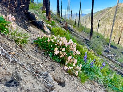
The trail started to descend into Safety Harbor Creek drainage, dropping down from 6,400 feet to a little to about 5,300 feet through a series of switchbacks. I can't say I love a trail that starts with 1,000 foot plus descent, and if I ever do this again, I would definitely consider coming in via the Safety Harbor Creek trail. That would add about a mile to the trip, but remove 1,000 feet of elevation gain, and is less likely to have snow on the road. During the descent, I caught my first sighting of Tweedy's Lewisia. I have only seen it once in the Chelan Valley around 25 mile creek, but saw quite a bit of it on this hike.
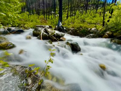
On the way down into Safety Harbor Creek drainage I had to get across a rather large stream coming down from North Navarre Peak. Not wanting to get my feet wet at this point, I found a log and made my way across. The log happened to break as I was nearly across, and while I was able to jump to a rock, I ended up skinning my shin while jumping. It wasn't too bad of a gash, but wouldn't be my only one on the day. I quickly checked the map, checking where I would need to get across Safety Harbor Creek, concerned that might be quite difficult. It didn't look like I had to cross it to get up to Uno Peak, but I would certainly be crossing it after coming down from Uno Peak. Once past the junction with the Safety Harbor Creek trail, I veered off trail to get a better look at the Creek. There was a lot of water flowing, but I saw a couple of spots where I could get across. Worst case scenario I could hike up to this spot if it was impassable lower down.
Satisfied I would be able to get across Safety Harbor Creek, I continued along the Summit Trail, as it gradually started gaining elevation. I picked up the pace a bit, as I was behind schedule, not only from getting my car out of the snow, but in trying to keep my feet dry getting across a couple of creeks had ate up some time as I looked for suitable spots to cross. I passed by a large stand of dead trees, likely due to the fire, with the northern face of Uno peak looming in the background.
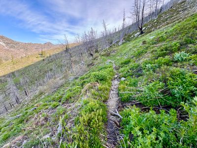
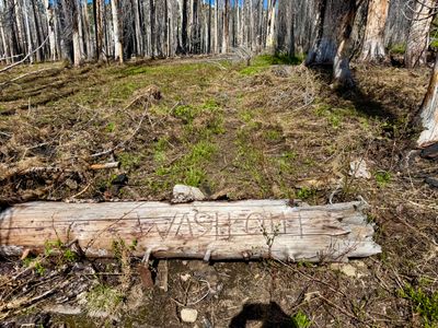
The inclination of the trail increased as I progressed up what I believe is called Miner's Basin. Even though the area, like the rest of the hike, has been decimated by fire, it was still pretty, with wild flowers and some green meadows. Eventually I reached the junction with Uno Peak trail and took a left. The Summit trail continues up quite a bit to Deadman's Pass and is another area I need to check out. Within the first 20 feet of the Uno Peak trail, there was a log across it with the word "Washout" carved into it. That gave me pause, should I continue on I wondered. I reasoned that these trails were mostly used by dirt bikers, and the washout was probably something I could easily get around on foot, but would pose a problem for a dirt bike, and fortunately, this proved to be the case, with a small washout on a steep section towards the end of the Uno Peak trail which was easy to get around on foot.
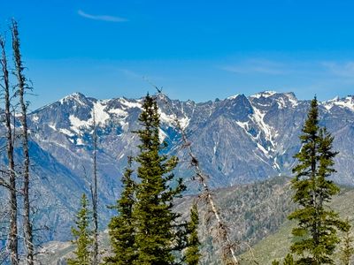
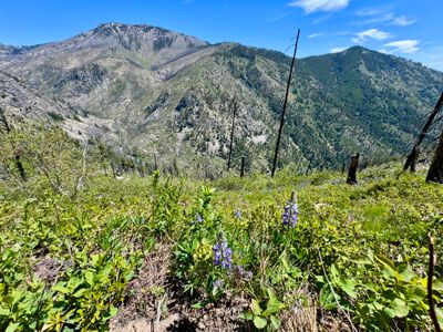
The trail mellowed out as it wrapped around Miners Basin, passing through a mixture of open meadows and fire scorched terrain. From this vantage point, I could see a lot more snow on Uno and Ferry Peak and the ridge between them that I would be hiking through. This was a northern aspect, so I was hoping it would only be a short amount of travel through snow, and the coverage didn't look consistent.
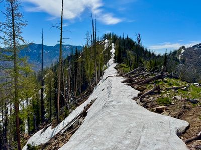
As I progressed along the trail under Ferry Peak, I started to encounter snow. It was intermittent and not much of an irritant at first, however as I continued it became more contiguous and at a couple of points I had no idea where the trail was and just continued up the side of the mountain. I was able to pick the trail back up, but upon reaching the ridgeline, there was quite a wall of snow, likely wind transported during the winter. I had to kick steps into and use my bare hands to get myself up. I was glad when that was over, and the other side had next to no snow.
I motored along the trail, anxious to get up to the top of Uno Peak which was roughly the halfway point for me. While I couldn't see Lake Chelan from this vantage point, I could see the mountains on the other side of the lake, including Pyramid Mountain, and while they didn't have much snow, there was enough this late in the season in one of the drainages going down to the lake for me to make a mental note as a possible ski run.
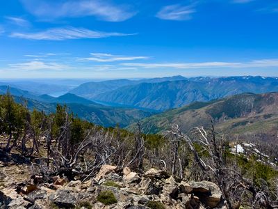
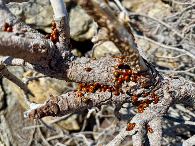
As the trail left the ridge and began wrapping around Uno Peak, I left the trail and began hiking up towards the summit, as the Uno Peak trail never reaches the top. It was slow going, with fairly steep terrain and some scree fields. I got back up on the ridge and then followed the ridge up to the Summit. At the top, I finally had some views of Lake Chelan. There was also a crazy amount of lady bugs all over the rocks, easily a couple of thousand. Looks like I had stumbled upon a lady bug party on the summit of Uno Peak. It was hard to find a place to sit that wasn't covered in them.
After eating and hydrating, I began the ascent back down to the trail on the southwest ridge, which had a more moderate incline and no rocky sections. After a while of descending I picked up the Uno Peak trail and started following that down and around Uno Peak. I saw a lot more Tweedy's Lewisia on the way down. This section of the trail was rough, there were a lot of downed trees to navigate around, and many sections that were overgrown, which didn't feel good in shorts and a t-shirt, and my pace slowed considerably.
I was more than half way through the hike, so there was no point in even thinking about turning around. I kept going, and looped around back over into the Safety Harbor Creek drainage, and was able to see part of the Safety Harbor Trail a thousand feet below me.
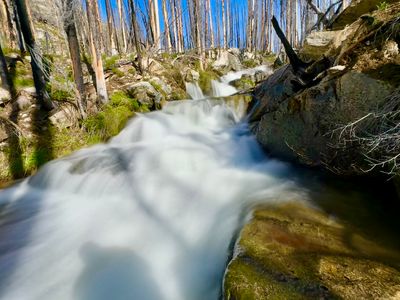
After what felt like an interminable amount of time I finally reached Safety Harbor Creek and had to find a way to get across. After a little bit of searching I found a log across the creek and began to inch my way across it. About a third of the way across, I wasn't feeling good about the integrity of the log, and had thoughts of my earlier attempt at a log crossing, and decided to abandon that effort. After some more searching, I found a place where I could ford through the creek with the help of some logs for handrails. At this point I was tired and hot, and getting completely soaked actually seemed like a good idea. The creek wasn't too deep, never really getting above my waist.
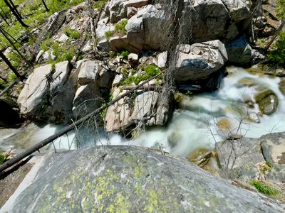
With the uncertainty of the creek crossing out of the way, I was feeling good, albeit tired. I located the Uno Peak Trail and soon reached the Safety Harbor Creek Trail. This section of the trail is very pretty, with the creek running below and lots of Tweedy's Lewisia. There were a number of nice spots to stop and take a break, but I was anxious to get back to the car, especially as it was the afternoon now and the temps were rising fast.
I gained 1,000 feet on the Safety Harbor Trail before reaching the junction of the Summit Trail. Consulting the map, I had another 1,200 feet of elevation gain and close to 3 miles back to the car. I had gone through most of my 2 liters of water, and decided to ration a bit, as I didn't bring a filter. I had to cross a lot of streams along the way, and started dipping my hat in the water and dumping the cold water on my head.
Eventually the hot weather and rationing of water caught up with me. I was starting to feel dizzy and needed a break. I filled up my water bottle with mountain fresh cold water and chugged it down. I was more concerned with dehydration than giardia at this point. I sat down on a log next to a stream, used my jacket to block the sun, and hydrated, drinking over a liter of water. Eventually I felt better, filled up my water bottle again and made the trek back up to the trailhead and onto my car. It was a cool hike, and I'm glad I did it, but probably not one I will do again anytime soon.