
Entiat — Washington State
Hiking in
Entiat
From Silver Falls to the high Cascade ridgelines — trails for every level in the Entiat Valley.
All Things to Do →beExploring / Entiat
Overview
The Entiat Valley offers hiking that most visitors to central Washington never discover. Silver Falls is the standout accessible hike, easy enough for families and impressive enough for anyone. Deeper in the valley, the Mad River Trail and high-country routes like Angle Peak and Devil's Backbone reward those willing to put in the miles.
Every hike here sits within a quieter corner of the Okanogan-Wenatchee National Forest. Expect far fewer crowds than comparable trails near Lake Chelan or Leavenworth.
beExploring / Entiat
Hike Directory
Browse all 6 hikes in the Entiat area. Use the map layers control to toggle between hike pins and trailhead pins, or remove trail lines from view. Click Show on Map to locate a hike on the map.
Angle Peak Loop
Why Go
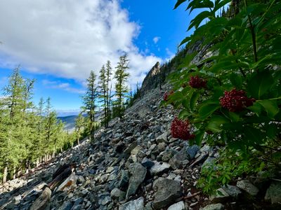
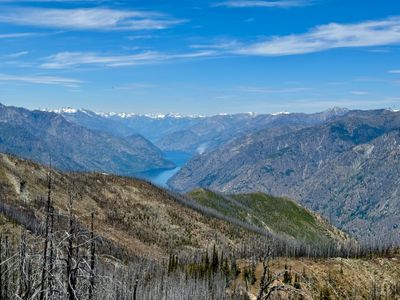
A full-day loop in the mountains above Lake Chelan, reached by a long drive to the trailhead. At 11 miles and 2,600 feet of gain, the ridge delivers panoramic views across both the Chelan and Entiat Valleys and a stand of larches that adds color in fall. A solid outing for experienced hikers who don't mind the commitment to get there.
Statistics
- Length: 11 miles, loop
- Elevation Gain: 2,600 ft
- High Point: 6,890 ft
- Difficulty: Strenuous
- Best Season(s): Jul – Oct
Devil's Backbone
Why Go
One of the most demanding and rewarding hikes in the backcountry above Lake Chelan, with a challenging ridge traverse and sweeping views of the lake and surrounding peaks. An outstanding larch display adds color in fall. At 11.8 miles one way with significant elevation gain, best treated as an overnight or shuttle hike. The views from the ridgeline are exceptional.
Statistics
- Length: 11.8 miles, one way
- Elevation Gain: 3,560 ft
- High Point: 7,150 ft
- Difficulty: Strenuous
- Best Season(s): Jul – Oct
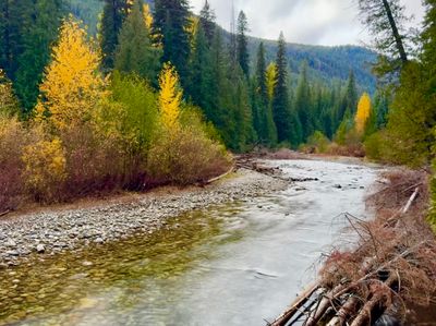
Lower Mad River
Why Go
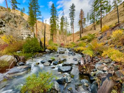
The Lower Mad River Trail follows the river through dense pine, fir, and cedar forest for over 14 miles into the backcountry. The first 3 miles are relatively flat and excellent for families, with the river audible throughout and frequent wildlife sightings. Hikers can turn around whenever they like. Even a short out-and-back from the Pine Flat Campground trailhead delivers a beautiful stretch of valley trail.
Statistics
- Length: 15.5 miles, one way
- Elevation Gain: 4,100 ft
- High Point: 4,305 ft
- Difficulty: Strenuous
- Best Season(s): May – Oct
Mills Canyon
Why Go
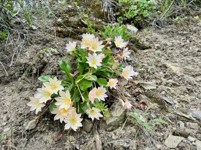
A quieter alternative to the more popular Entiat Valley hikes, Mills Canyon climbs through open ponderosa pine terrain above the Columbia River with sweeping views of the valley and surrounding ridgelines. Spring brings wildflowers including Tweedy's Lewisia, a highlight for anyone visiting in May or early June. Significantly fewer crowds than Silver Falls.
Statistics
- Length: 3 miles, roundtrip
- Elevation Gain: 800 ft
- High Point: 3,050 ft
- Difficulty: Moderate
- Best Season(s): Apr – Oct
Silver Falls Interpretive Trail
Why Go
A short, easy loop through the forest near Silver Falls Campground with interpretive signs explaining the ecology and geology of the Entiat Valley. A good option for families with young kids or anyone wanting a peaceful walk without elevation. Pairs well with the main Silver Falls hike for a complete visit to the campground area.
Statistics
- Length: 1 mile, roundtrip
- Elevation Gain: 40 ft
- High Point: 2,380 ft
- Difficulty: Easy
- Best Season(s): May – Oct
Silver Falls
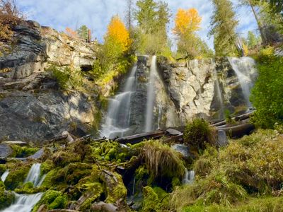
Why Go
The standout short hike in the Entiat Valley, just 1.7 miles round trip to a 141-foot waterfall surrounded by old-growth Douglas fir and cedar. The trail ends at a viewpoint where you can walk directly behind the falls. Accessible for most skill levels and suitable for families. Best in spring when flow is strongest, but worth visiting any time the road is clear.
Statistics
- Length: 1.7 miles, roundtrip
- Elevation Gain: 580 ft
- High Point: 3,010 ft
- Difficulty: Easy
- Best Season(s): May – Oct
beExploring / Entiat
Hike Comparison
Compare all Entiat hikes side by side to find the right trail for your trip.
| Name | Distance | Difficulty | Elevation Gain | Best Season(s) |
|---|---|---|---|---|
| Angle Peak Loop | 11 miles, loop | Strenuous | 2,600 ft | Jul – Oct |
| Devil's Backbone | 11.8 miles, one way | Strenuous | 3,560 ft | Jul – Oct |
| Lower Mad River | 15.5 miles, one way | Strenuous | 4,100 ft | May – Oct |
| Mills Canyon | 3 miles, roundtrip | Moderate | 800 ft | Apr – Oct |
| Silver Falls | 1.7 miles, roundtrip | Easy | 580 ft | May – Oct |
| Silver Falls Interpretive Trail | 1 mile, roundtrip | Easy | 40 ft | May – Oct |
beExploring / Entiat
Family-Friendly Hikes
Traveling with kids? These Entiat trails offer shorter distances, easier terrain, and strong payoffs without a major climb.
Silver Falls
Short 1.7-mile round trip to a 141-foot waterfall you can walk behind. Easy terrain, big reward.
Silver Falls Interpretive Trail
A flat 1-mile loop with interpretive signs through the forest near Silver Falls Campground.
Lower Mad River (first 3 miles)
Flat riverside trail through forest with wildlife sightings. Turn around whenever — the trail just keeps going.
beExploring / Entiat
Trail Conditions
beExploring / Entiat
Explore Entiat
More guides for planning your trip.
beExploring / Entiat