
Winthrop — Things to Do
Best Hikes
Near Winthrop
From a gentle lakeside walk to one of the best alpine loops in Washington — trails for every level in the Methow Valley and North Cascades.
Things to Do Guide →beExploring / Winthrop
Overview
Winthrop sits at the eastern edge of the North Cascades, placing it within an hour of some of the most dramatic alpine hiking in Washington. Highway 20 runs west from town through Washington Pass and Rainy Pass, opening access to trails like Maple Pass Loop, Blue Lake, and Cutthroat Lake that rank among the finest in the state. Closer to town, the Twisp River valley offers long valley hikes and a backcountry pass route into the Pasayten Wilderness.
Use the interactive map to explore all hikes and trailheads in the area, or browse the trail directory and check current conditions before you go.
beExploring / Winthrop
Hike Directory
Browse all 6 hikes accessible by car from Winthrop. Use the map layers control to toggle between hike pins and trailhead pins, or remove trail lines from view. Click Show on Map to locate a hike on the map.
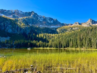
Most scenic alpine lake
Blue Lake
Why Go
A shorter and more accessible alternative to Maple Pass, Blue Lake is a 4.4-mile round trip through forest and meadow to a glacially carved lake framed by Liberty Bell Mountain and the Early Winters Spires. The turquoise water and dramatic granite backdrop make it one of the most photographed destinations on the North Cascades Highway. At 1,100 feet of gain over 2.2 miles, the climb is steady but manageable for most hikers. The Washington Pass trailhead is about 47 miles west of Winthrop on Highway 20.
Statistics
- Length: 4.4 miles, roundtrip
- Elevation Gain: 1,100 ft
- High Point: 6,254 ft
- Difficulty: Moderate
- Best Season(s): Jul – Oct
Best hike for fall larches
Cutthroat Lake
Why Go
The most accessible North Cascades hike from Winthrop, Cutthroat Lake is a gentle 4-mile round trip through a forested valley to a turquoise lake beneath dramatic rocky peaks. At just 500 feet of elevation gain, the trail is approachable for families and hikers of all ability levels. In fall, the surrounding larch trees erupt in gold, drawing photographers and hikers from across the Pacific Northwest. Extending to Cutthroat Pass adds significant elevation gain and panoramic ridge views for those wanting more. A Northwest Forest Pass is required at the Cutthroat Pass Trailhead, about 35 miles west of Winthrop on Highway 20.
Statistics
- Length: 4 miles, roundtrip
- Elevation Gain: 500 ft
- High Point: 4,950 ft
- Difficulty: Easy
- Best Season(s): Jun – Oct
Falls Creek Falls
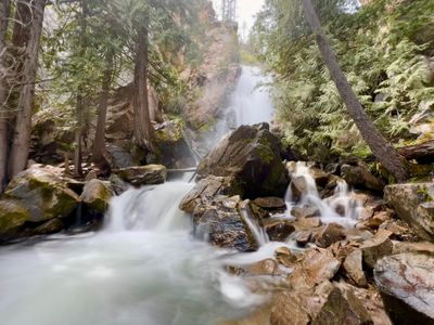
Why Go
Just 11 miles from downtown Winthrop up the Chewuch Road, Falls Creek Falls is one of the most accessible waterfall hikes in the Methow Valley. A flat, paved quarter-mile path leads to a lower viewpoint of the first falls, suitable for families with young children. A steeper dirt trail continues to the top of the first cascade and on to a second falls, with 700 feet of gain over 2.5 miles round trip. The combination of an easy start and a more rewarding climb for those who continue makes it one of the best quick outings near Winthrop.
Statistics
- Length: 2.5 miles, roundtrip
- Elevation Gain: 700 ft
- High Point: 2,900 ft
- Difficulty: Moderate
- Best Season(s): May – Oct
Best hike in Washington
Maple Pass Loop
Why Go
Consistently ranked among the top hikes in Washington State, the Maple Pass Loop is a full-day circuit through open alpine meadows with sweeping views across the North Cascades. The route climbs past Lake Ann to a high ridge connecting Maple Pass and Heather Pass, with views stretching across peaks and subalpine lakes in every direction. Fall larch season, from late September through mid-October, transforms the loop into one of the most photogenic hikes in the Pacific Northwest. At 7.2 miles and 2,100 feet of gain, it is a full workout but accessible to fit day hikers. The Rainy Pass trailhead is about 52 miles west of Winthrop on Highway 20.
Statistics
- Length: 7.2 miles, loop
- Elevation Gain: 2,100 ft
- High Point: 6,870 ft
- Difficulty: Moderate
- Best Season(s): Jul – Oct
Best backcountry day hike
Twisp Pass
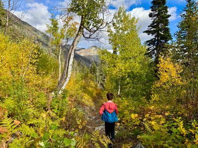
Why Go
A challenging but rewarding full-day hike that climbs from the Twisp River valley to a high alpine pass on the boundary of the Pasayten Wilderness. The 8.6-mile round trip gains 2,400 feet through forest, open meadows, and talus fields before reaching sweeping views into the remote country beyond. Wildflowers cover the upper meadows in midsummer, and the sense of backcountry solitude at the pass is striking even on a day hike. Strong hikers can continue down into the Bridge Creek drainage or explore side ridges near the pass. A Northwest Forest Pass is required at the Gilbert Trailhead, about 25 miles from Winthrop up the Twisp River road.
Statistics
- Length: 8.6 miles, roundtrip
- Elevation Gain: 2,400 ft
- High Point: 6,064 ft
- Difficulty: Hard
- Best Season(s): Jul – Oct
Best long-distance trail
Twisp River
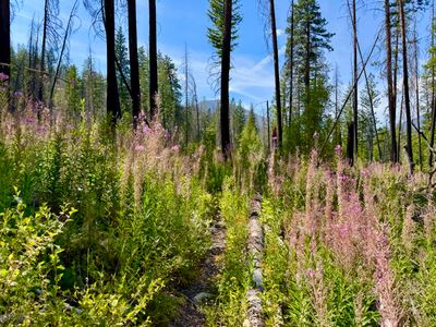
Why Go
A long, low-gradient trail following the scenic Twisp River Valley deep into the Okanogan-Wenatchee National Forest. The 14-mile one-way route is most commonly done as a point-to-point backpacking trip or a shorter out-and-back from one of multiple trailheads along the valley. The gentle grade, old-growth forest, and constant river presence make it one of the most pleasant long-distance trails in the area, with wildlife sightings common throughout the riparian corridor. Multiple access points along the valley allow easy customization of the day's length.
Statistics
- Length: 14 miles, one way
- Elevation Gain: 2,000 ft
- High Point: 3,705 ft
- Difficulty: Moderate
- Best Season(s): May – Oct
beExploring / Winthrop
Hike Comparison
Compare all five hikes side by side to find the right trail for your trip.
| Name | Distance | Difficulty | Elevation Gain | Best Season(s) |
|---|---|---|---|---|
| Blue Lake | 4.4 miles, roundtrip | Moderate | 1,100 ft | Jul – Oct |
| Cutthroat Lake | 4 miles, roundtrip | Easy | 500 ft | Jun – Oct |
| Falls Creek Falls | 2.5 miles, roundtrip | Moderate | 700 ft | May – Oct |
| Maple Pass Loop | 7.2 miles, loop | Moderate | 2,100 ft | Jul – Oct |
| Twisp Pass | 8.6 miles, roundtrip | Hard | 2,400 ft | Jul – Oct |
| Twisp River | 14 miles, one way | Moderate | 2,000 ft | May – Oct |
beExploring / Winthrop
Conditions
Weather Forecast
beExploring / Winthrop
Plan Your Trip
beExploring / Winthrop