Click on an item on the map to view information about it

Antilon Overlook
Manson,
Washington
overview
LENGTH : 2.2 miles, roundtrip
ELEVATION GAIN : 300 ft.
TYPE : hike
HIGH POINT : 2,140 ft.
Note, as of 2026 the old forest service road the hike used to follow is in very rough shape and not worth the effort. About a half mile in, there is a large obstruction of dirt, rocks and branches blocking the trail, and past that there are consistent downed trees, trenches and downed shrubs, making it difficult to proceed.
If you are looking to get outstanding views of Lake Chelan, and don't feel like the uphill on the nearby Fourth of July Mountain hike, this hike will take you around and through a large grove of quaking aspen before delivering on the views of Lake Chelan. And during the spring, you can expect wildflowers galore in addition to views of the lake. This isn't an official hiking trail, rather the remnants of what looks to be an old forest service road, and access is a little tricky (see below on directions) and there is no signage.
If starting your hike from Antilon Lake Campground, follow the faint trail past the lower pit toilet, which wraps around Upper Antilon Lake until it reaches a road. Follow this road for a couple of hundred feet until it intersects with Antilon Spur Forest Service Road, and take a left to begin the hike. The hike begins on Antilon Spur Forest Service Road 8200-115 next to Upper Antilon Lake, and the road quickly becomes overgrown in spots as it heads away from Lake Chelan (east and south ) before turning west through an aspen grove. In less than a half mile you will have full views of Lake Chelan, and after descending a bit and heading downlake, there is a nice ridge off the road that provides a great turnaround and break spot. While you can follow the road further, it continues on into Emerson Acres.
Placeholder in dev for ad
Directions
Follow the Grade Creek Road for 3.5 miles (pavement ends about 1.7 miles in), and if parking at Antilon Campground, take a left into the campground and follow the road (always stay right) down to the lower outhouse. Find a place to park and look for the connecting trail at the western edge of the road near the lake. If heading to Antilon Spur, follow Grade Creek for a couple hundred yards and take a left on Antilon Spur Road. Follow the road as far as you can, and find a suitable place to pull over.
Parking
Trip Reports
TOTAL MILEAGE : 1.2 miles, roundtrip
ELEVATION GAIN : 205 ft.
HIGH POINT : 2,305 ft.
I had taken my parents on this hike two years ago before they moved to the area, and while at their house for dinner on Sunday night, they mentioned the trail is in very rough shape. I decided to go take a look for myself, hoping that wasn't the case, and I could get in a nice walk with the dog, while enjoying wildflowers and views of the lake.
I decided to drive down Antilon Spur Forest Service Road, as there had been work done on it during the Pioneer Fire, and the top part looked ok. The bushes on the side of the road were starting to encroach, but I made it without scratching up my car, and found a dispersed camping site to pull off and begin the hike. Last time I had gone down a little lower, but the road had been pretty rough, and there was still a rutted out section, but it would have been fine for my Subaru Solterra.
Antilon Lake
I walked past Antilon Lake, where the stand of Aspen trees' light green leaves made a nice contrast with the Coniferous trees in the background. The osprey nest I had seen two years ago was gone, although I did see an osprey circling overhead. So far the road was in decent shape and I was hoping my parents had taken a different route.
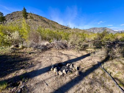
About a half mile from my car, there was a large obstruction of dirt, rocks and branches in the road , as well as a fire pit which looked like it had been recently used. This certainly hadn't been here two years ago, and was definitely man made.
End of the road
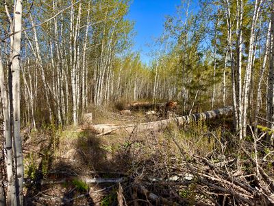
I picked my way through the obstruction, and my dog was able to do the same without too much effort. In front of me was a mixture of downed trees and shrubs, new growth coming up, and what appeared to be trenches in the ground. I know they had been doing some work in the area during the Pioneer Fire, and at first I thought this must be one of the fire breaks they created. But the road was an existing "break" in the vegetation, and now there was a lot more fuel, so it couldn't have been a deliberate fire break. I'm guessing they didn't want people using the old road and placed all the debris to let it go back wild.
Downed trees
I kept going along the old road, hoping it might get better farther up. It wasn't too hard to get through all the vegetation and downed trees, but it certainly wasn't enjoyable. And I was a little concerned my puppy, now 7 months old, might have some trouble, but I think he had an easier time finding his way than I did. Eventually I decided to bail on making it to the overlook with a nice view of the lake. It wasn't going to be fun walking back through this, and a quick consult of my track showed I could directly cut over to get back to my car. I had to pass through a dry creek bed, which was quite choked with vegetation, but found a spot that wasn't too bad.
Once across the dry creek bed, it was easy going. There weren't any thick stands of vegetation on this side and I was able to pick my way up the hill back towards the car. It was a southern facing slope, and there were a lot more flowers here, including Wax Currant, Longleaf Phlox, Pungent Desert Parsley and Dark-throated Shooting Star, in addition to the ever present Arrowleaf Balsamroot.
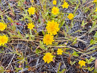
Sagebrush False Dandelion
As we climbed up the hill, we passed through some rocky areas. I was a little concerned we might run into rattlesnakes, as they are around Antilon Lake and this seemed like prime real estate for them. Fortunately, there were no encounters. My puppy Summit even found a nice spot to stand amongst the Arrowlead Balsamroot for a photo!
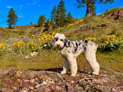
My puppy Summit
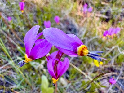
Dark-throated Shooting Star
Soon we were back in the car. It was a short hike, and a bit of a bummer that its no longer worth doing. But at least there are plenty of other hikes in the area. And we ran into my parents on the side of the grade creek forest road, and got a longer walk in with them and their dog.
TOTAL MILEAGE : 2.7 miles, roundtrip
ELEVATION GAIN : 340 ft.
HIGH POINT : 2,140 ft.
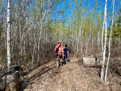
My parents were in town moving some initial items into their newly purchased house which they hope to permanently relocate to soon, and were looking to get their dogs out for an off leash run. They have been to the various trails at Echo Ridge a number of times, so I decided to change things up and head towards Antilon Lake, an area they had never been to.
The only other time I had done this hike, I had driven down Antilon Spur Forest Service Road, which was quite bumpy and overgrown. For this hike, we started from Antilon Campground, and I couldn't remember exactly where the unofficial trail left the campground to connect up with the road. There happened to be a family camping who had recently done the hike, and they pointed me in the right direction...
Upper Antilon Lake
We wrapped around upper Antilon Lake, scarring a number of ducks away as we passed by. We connected into the Antilon Spur forest service service road and shortly thereafter, spied an osprey nest atop an old tree in the distance. We were able to make out an osprey sitting in the nest, and as we continued hiking, saw the osprey fly off towards the lake.
Osprey nest
We continued along the old forest service road as it wound its way around towards the large aspen grove. The aspen trees had recently started budding, and it wasn't quite as scenic as the last time I came through with the limited leaves, but it was still pretty. There's something about walking through an aspen grove that I will never get tired of, especially when there is some wind and the quaking aspen earns its name.
Aspen grove
We continued along the overgrown road towards the lake, passing through more open terrain. There weren't nearly as many wildflowers in bloom as I expected. While there were some arrowleaf balsamroot showing, they looked past their prime. Last year I did this hike in May, and it was prime wildflower season, obviously this year the flowers had come much earlier.

First views of the lake
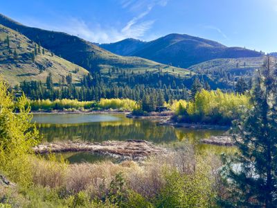
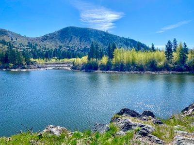
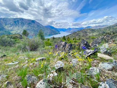
A short while later and we had unobstructed views of the lake and we departed the old forest service road to hike a short ways down a ridge to a nice vantage point overlooking the lake. While we have views of the lake from our house, this was a different perspective and its impressive to look uplake with the larger mountains still covered in snow.
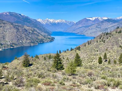
Lake Chelan
After a nice water and food break, we retraced our steps back along the old forest service road through the aspen grove, and back onto the unofficial trail which leads to Antilon Campground. A nice multi-generational family hike!
Comments
0No comments yet. Be the first to share your thoughts!
TOTAL MILEAGE : 2.2 miles, roundtrip
ELEVATION GAIN : 300 ft.
HIGH POINT : 2,140 ft.
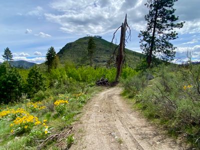
While on a ski tour on Fourth of July Mountain, I had come across a cool rock overlook on the bottom of my descent, and had then followed a snowmobile track out towards Grade Creek that looked to be on some sort of road. Looking at satellite photos showed faint outlines of a road, and I made a mental note to go back and explore once the snow was gone - it looked like it could be a fun hike to bring the family on.
As I pulled onto Antilon Spur Forest Service Road, the thought quickly crossed my mind that I might be better off pulling off on Grade Creek Road and walking down. The road didn't look that bad, but it was overgrown in spots and certainly didn't look like there was an option to turn around if things got ugly. But throwing caution to the wind, I continued down the road. Eventually I came to a short spot that was steep and rutted out, but I was able to get my Subaru down without bottoming out and I found a place to pull over and begin the hike.
Start of the hike
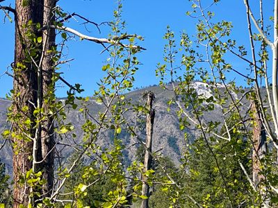
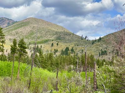
The road was obstructed by numerous hanging tree branches as it crossed a small dry gully, and on the other side it started heading east away from Lake Chelan. I had a nice view of the slope I had skied on Fourth of July Mountain, and eventually the road started heading west toward Lake Chelan through an aspen grove, which I had gone through on my ski tour.
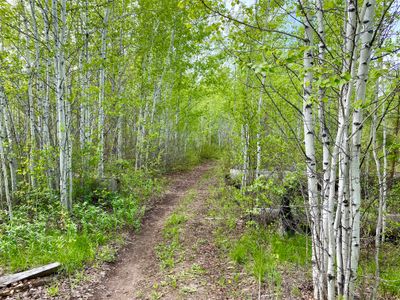
Aspen grove near Upper Antilon Lake
A short while later, Lake Chelan came into view and it was quite the site with the wildflowers still in bloom in the area. The road was starting to look more like a trail at certain spots, but in general the two tire tracks were fairly well defined. In addition to some recent mountain bike tracks on the road, I did notice some other tracks that might have been an ATV or side-by-side. While I hadn't heard of this road/trail before, it obviously gets some use.
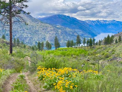
First views of Lake Chelan
Wildflowers and Lake Chelan
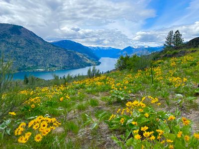
The trail began gently descending, and then a bit further down, started to trend more south and downlake. I noticed a small rocky ridge coming off the road, and ventured off the road and onto the ridge to snap a couple of photos. I was tempted to sit down and enjoy the scenery, but had plans with my family, and had to quickly turn around and start making my way back.
More views of Lake Chelan
It was a little over a mile back with minimal uphill and the hike went by fast. Across the valley I could see slopes covered in arrowleaf balsamroot flowers. Even though it was far away, the slopes were bright yellow, and I tried to get some photos of them, but it was hard to capture.
Arrowleaf Balsamroot flowers on the faraway slopes
Back at the car, I was able to turn around and make it back up the rutted out section without issues. I ventured over to Antilon Lake Campground to quickly see if it was possible to link up with this hike and found a faint trail that connects into the road. Excited to take the family on this hike in the near future, and I will probably park in Antilon Lake Campground this time, although my son might have fun driving down Antilon Spur road.
Comments
0No comments yet. Be the first to share your thoughts!
Comments
0No comments yet. Be the first to share your thoughts!