Click on an item on the map to view information about it
beExploring · Trip Reports · Washington · Winthrop
Cutthroat Lake
The most accessible North Cascades hike from Winthrop, Cutthroat Lake is a gentle 4-mile round trip through a forested valley to a turquoise lake beneath dramatic rocky peaks. At just 500 feet of elevation gain, the t…
Plan This Trip
At a Glance
straighten
Distance
4 miles, roundtrip
trending_up
Elevation Gain
500 ft
landscape
High Point
4,950 ft
backpack
Activity
Hike
Best For
Kid FriendlyFall LarchesAlpine LakeNorthwest Forest PassPhoto Highlights · October 2024
Jump to Trip Report →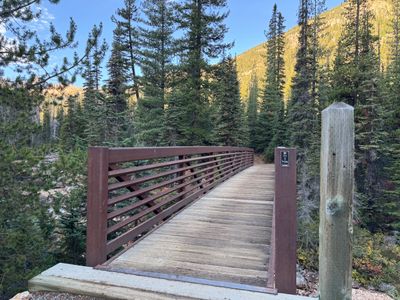
Plan This Trip
Why Go
Cutthroat Lake is a rare hike in the North Cascades - a low mileage and low elevation gain hike that ends at a small but pretty alpine lake circled by towering mountains, and when in season, stands of golden larch. The only downside : it's a very popular hike, and you shouldn't expect a serene and crowd free alpine experience. That being said, it's a beautiful hike and the trail to Cutthroat Lake is reasonably wide for a hiking trail, meaning parties can typically pass each other without having to step aside.
The trail crosses Cutthroat Creek shortly after the trailhead on a sturdy bridge, and then proceeds to gently climb up the side of the valley a couple of hundred feet above the creek on a couple of switchbacks. Follow the trail for a little over a mile and half, enjoying views of Cutthroat Peak before the trail splits - head to the left for Cutthroat Lake, and after a small crossing on Cutthroat Creek (no bridge, but you can get across the water on logs and rocks), you will arrive at Cutthroat. If you want to extend the hike, proceed 1,800 feet and 3.2 miles to Cutthroat Pass, otherwise retrace your steps back to the trailhead.
The trail crosses Cutthroat Creek shortly after the trailhead on a sturdy bridge, and then proceeds to gently climb up the side of the valley a couple of hundred feet above the creek on a couple of switchbacks. Follow the trail for a little over a mile and half, enjoying views of Cutthroat Peak before the trail splits - head to the left for Cutthroat Lake, and after a small crossing on Cutthroat Creek (no bridge, but you can get across the water on logs and rocks), you will arrive at Cutthroat. If you want to extend the hike, proceed 1,800 feet and 3.2 miles to Cutthroat Pass, otherwise retrace your steps back to the trailhead.
Placeholder in dev for ad
Plan This Trip
Route & Map
Plan This Trip
Getting There
directions_car
Directions
From the Puget Sound, head east on Highway 20 and roughly 4.5 miles after Washington Pass, turn left onto NF-400 and drive 1 mile up to the end of the road / Cutthroat Lake Trailhead. If coming from the east, drive west on Highway 20 for 12.5 miles past Mazama, and turn right onto NF-400.
local_parking
Parking
The Cutthroat trailhead ends in a circular drive with two sizable parking lots on the north and sound end, with two vault toilets available in the south end. During busy weekends, it is acceptable to park on the side of the road - the forest service will usually sign which side is forbidden, but typically parking is on the north side of the road. Northwest forest pass is required, and there is a receptacle to pay for a single day pass.
edit_note
Field Notes · Personal Trip Report
Golden Larches, Three Generations
We brought my parents, their elderly dogs, and our 9-year-old up to Cutthroat Lake during peak larch season and discovered the crowds weren't nearly as overwhelming as we'd feared.
calendar_today October 6, 2024
straighten 4.2 miles, roundtrip · 535 ft gain
chat 0 comments
Larch season was here, and we landed on Cutthroat Lake as the perfect place for a family hike, with my wife, 9 year old son, both my parents and their dogs, one of whom is 14 years old. I had originally wanted to take the family to Cutthroat Lake this summer for a hike, but the Easy Fire had kept me away and it had been on my to do list ever since. I was a bit concerned about the crowds given it was Larch season, and a friend had mentioned there were hundreds of people at Ann Lake this past Thursday, but decided we would give it a go.
Arriving at 10am, the main parking lots were full and we parked along the north side of the road, a couple of hundred yards from the trailhead. In retrospect, I was pleasantly surprised with the number of people. We had a couple groups of mountain bikers pass us on the way up, and a couple of small groups coming down, while at the lake there were only a handful of people. On our way back to the car, we definitely passed more groups coming up, but I want to say there were less than 50 people. Not too bad for peak larch season!
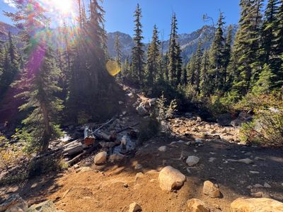
It was cold, with snow visible on the upper peaks, and fortunately my mother had brought gloves, as my son's hands were quite cold. It surely felt like fall as we started out on the trail and passed over Cutthroat Creek.
Bridge over Cutthroat Creek
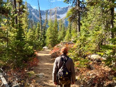
The trail switchbacks a couple of times after the bridge, putting us a couple of hundred yards above the creek, and then proceeded directly up the valley. It's a nice trail, fairly wide for a hiking trail and there is really no sustained elevation gain, it's very gradual. Within the first half mile, you also get views of Cutthroat Peak, and we could see the larches and snow on the mountainside.
My dad hiking along Cutthroat Pass trail
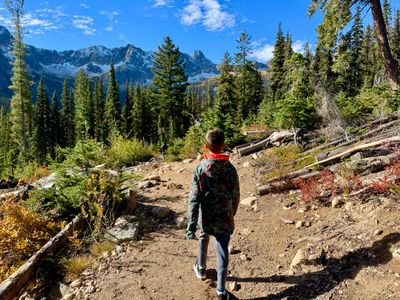
While the trail is a mix of forest and more open areas, we quickly warmed up hiking, and the temperatures steadily rose as the day progressed. While we could see our breath when we first left the car, that wasn't the case a half hour into the hike.
My son hiking
A little over a mile and a half into the hike we reached the junction with the Cutthroat Lake trail and descended a small amount down towards Cutthroat Creek. There was a small crossing sans bridge, but it was fairly easy to get across via logs and rocks, although my parent's 14 year old dog took her time wading through the stream, seeming to lap up water in between every step.
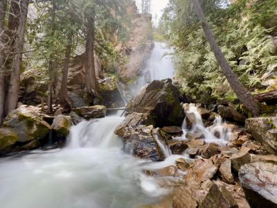
Cutthroat Creek
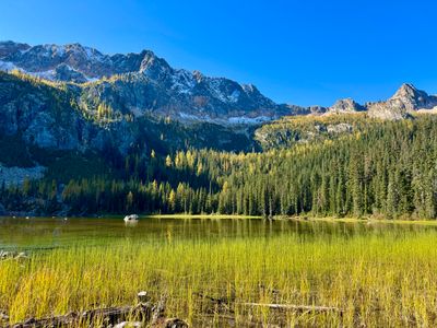
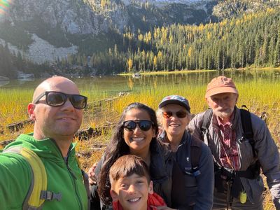
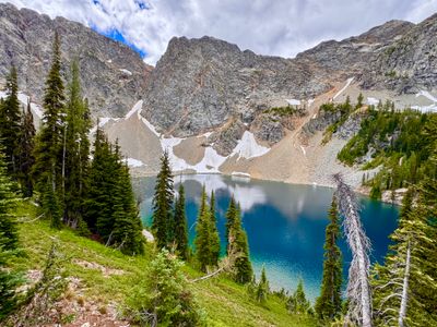
There was a small amount of up and down along the Cutthroat Lake trail, but before long we were on the banks of the lake with amazing views of the surrounding mountains, which had a small amount of snow on the upper sections. The larches were just coming into color, I'm thinking the next weekend might have been primetime, but it was still very scenic. And there were only a handful of people spread out around the lake, so it felt peaceful.
Cutthroat Lake
We took a family selfie, snapped some more photos of the lake and then began the hike back to the car.
Family selfie
It's a great family hike in the North Cascades, one of the few that combines a lake and beautiful scenery with low mileage and elevation gain. And the crowds weren't too bad for larch season.
Comments
on this trip report · Oct 2024
More From The Area
Nearby Trip Reports
beExploring / Winthrop
Comments
0No comments yet. Be the first to share your thoughts!