Click on an item on the map to view information about it
beExploring · Trip Reports · Washington · Chelan
Cutthroat Loop
A gentle riverside loop near Chelan perfectly suited for families and beginners. Minimal elevation, river access, and wildflowers in spring make this an easy choice for a relaxed outing close to town.
Plan This Trip
At a Glance
straighten
Distance
3 miles, roundtrip
trending_up
Elevation Gain
240 ft
landscape
High Point
1,020 ft
backpack
Activity
Hike
Best For
RiverDogs AllowedNo Pass RequiredKid FriendlyWildflowersClose to TownPhoto Highlights · March 2026
Jump to Trip Report →
Plan This Trip
Why Go
The Cutthroat Loop is located off the Eagle Trail and provides for a nice hike along the bank of the Chelan River. The loop itself is .7 miles, but the total hike including the Eagle Trail and the short section along the Reach 1 trail make it a 3 mile round trip hike. This is a great wildflower hike in the spring. The hike is best done in the mornings in the summer as the trail doesn't have any shade, and pay attention to where you step, as rattlesnakes are occasionally encountered during the summer.
From the Chelan Butte Trailhead, follow the Reach One trail for .4 miles, and then take the Eagle Trail for .7 miles at which point you will see signage for the start of the Cutthroat Loop on your left. Start here to here the loop clockwise, or proceed a couple hundred more yards on the Eagle Trail to catch the loop counter-clockwise.
From the Chelan Butte Trailhead, follow the Reach One trail for .4 miles, and then take the Eagle Trail for .7 miles at which point you will see signage for the start of the Cutthroat Loop on your left. Start here to here the loop clockwise, or proceed a couple hundred more yards on the Eagle Trail to catch the loop counter-clockwise.
Placeholder in dev for ad
Plan This Trip
Route & Map
Plan This Trip
Getting There
directions_car
Directions
From Chelan, take the Sanders Street Bridge across the river and take your first left on E Farnham Ave, which turns into Saunders St. Turn left onto E Iowa St, and you will see the parking lot on your left in .2 miles.
local_parking
Parking
There is a decent sized parking lot at the Chelan Butte Trailhead with a porta-potty, and no parking permits are required. If the parking lot is full, park on the side of the road.
edit_note
Field Notes · Personal Trip Report
3
Trip Reports
I've hiked Cutthroat Loop 3 times — pick a visit to read its full report.
Early Blooms, Summit's Way
My pup and I caught the first wildflowers of spring along the Chelan River—arrowleaf balsamroot and a surprise lupine bloom hinted at peak color just weeks away.
calendar_today March 31, 2026
straighten 3 miles, roundtrip · 315 ft gain
chat 0 comments
It was time for a quick off-leash hike with my puppy Summit, and we headed over to the Chelan Gorge. The arrowleaf balsamroot was starting to show around my house, and I was curious to see how the display was around the Gorge. The start of the hike along Reach 1 trail had no wildflowers in bloom - I guess I can't really recall seeing many wildflowers along this stretch.
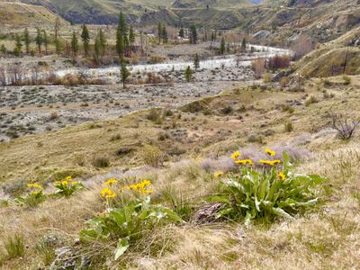
As we proceeded down Reach 1 towards the Chelan River, we could start to see some arrowleaf balsamroot, and once on the Eagle Trail, there was a good amount of wildflowers. It's still not at peak, but I think it's only a couple of weeks away at this elevation.
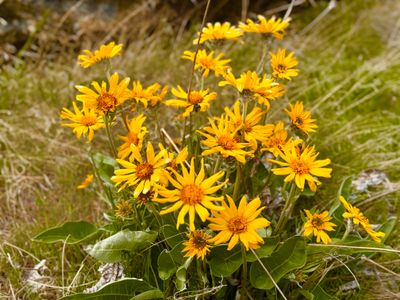
Arrowleaf balsamroot overlooking the Chelan River
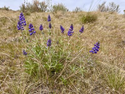
Farther along the trail, I was pleasantly surprised to see a couple of Lupine in bloom. I hadn't seen any in bloom around my house, and this was the only occurrence during this hike. I feel like Lupine is usually coming in around the tail end of the Arrowleaf balsamroot season. Curious to see if this season is different.
Lupine already in bloom
I had my puppy off-leash, as he is good about staying close to me when hiking. However, he still has a tendency to get overly excited around other people and jump on them, so as a couple people came jogging up the trail towards us, I had to put him on the leash and restrain him. Hopefully in the coming months he settles down and we can teach him not to jump on people.
We followed the trail down past the Aspen groove, where the leaves were just starting to come in. There were a good number of other wildflowers coming into bloom, including Phlox, Milkvetch and a couple of more I couldn't identify, because I didn't take a photo and can't really remember what they look like. Note to self, take a good quality photo of the flower so I can figure out what it is after the hike...
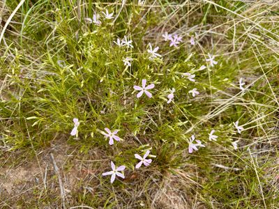
Phlox
Upon reaching the first intersection with the Cutthroat Loop, we took off on the loop, hiking it in a clockwise direction. Once the trail parallels the riverbank, I found a spot to get down to the water's edge for my dog to grab a drink. It was a little steeper and deeper than expected, and he fell into the river while trying to get water. He was scrambling to get back up onto the bank, so I gave him a hand, and we moved a little farther down where there was a better spot for him to drink.
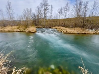
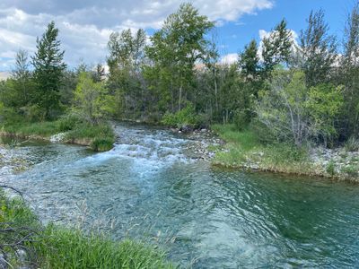
Chelan River
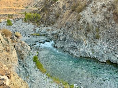
We completed the loop, and started our way back on the Eagle Trail, stopping to take some more photos of wildflowers and the Chelan River. The river was lower than is typical in the spring, likely due to our horrible winter and low snowpack. They have to fill up the lake and aren't releasing as much water into the river.
Another photo of Arrowleaf balsamroot
Although the day remained cloudy, it was good to get the dog out for some exercise and I'm excited for the wildflower season to kick off!
Comments
on this trip report · Mar 2026
More From The Area
Nearby Trip Reports
beExploring / Lake Chelan
Comments
0No comments yet. Be the first to share your thoughts!