Click on an item on the map to view information about it
beExploring · Trip Reports · Washington · Wenatchee
Sage Hills Trail
The best year-round trail network close to Wenatchee, with rolling singletrack through open sagebrush, continuous Columbia River Valley views, and good spring wildflowers. Multiple loop options suit every pace, from s…
Plan This Trip
At a Glance
straighten
Distance
4.5 miles, one way
trending_up
Elevation Gain
1,300 ft
landscape
High Point
1,834 ft
backpack
Activity
Hike
Best For
WildflowersDogs AllowedNo Pass RequiredClose to TownPhoto Highlights · July 2024
Jump to Trip Report →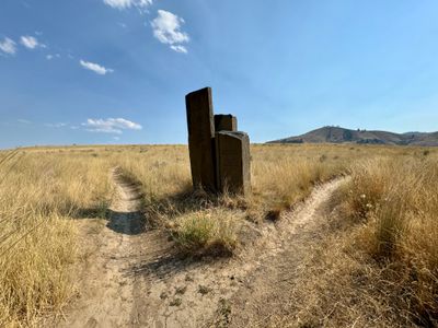
Plan This Trip
Why Go
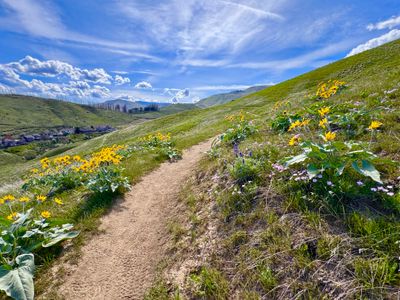
Located within the city of Wenatchee, the multi-use The Sage Hills Trail winds through the Wenatchee Foothills and provides outstanding views of Wenatchee and the Columbia River. It's a very popular trail in the spring when the hills are blanketed in wildflowers like arrowleaf balsamroot and lupine. The Sage Hill Trail is part of a trail system located within the Horse Lake Reserve and the Home Water Preserve, and the trail, along with other trails in the area, are closed from Dec. 1 through April 1 to protect winter mule deer habitat.
On the southern end of the trail in the area known as the Sage Hill Gateway, access is via the Day Drive Trailhead and Sage Hill Parking area, and makes for a nice out and back hike as the trail traverses along the hill before gradually climbing up into the valley. Horselake Trailhead provides access on the northern end, and can be combined with a number of other trails in the area like Old Ranch Road or the Canyon Overlook trail to form loops of varying lengths.
On the southern end of the trail in the area known as the Sage Hill Gateway, access is via the Day Drive Trailhead and Sage Hill Parking area, and makes for a nice out and back hike as the trail traverses along the hill before gradually climbing up into the valley. Horselake Trailhead provides access on the northern end, and can be combined with a number of other trails in the area like Old Ranch Road or the Canyon Overlook trail to form loops of varying lengths.
Placeholder in dev for ad
Plan This Trip
Route & Map
Plan This Trip
Getting There
directions_car
Directions
To access Day Drive Trailhead, proceed down 5th street west and turn right onto Surry Rd, continuing for 1 block. Turn left onto Lester Rd. and travel west until it is intersected by Day Rd. Follow Day Rd for 1 block and then turn left onto Day Drive which will wind uphill and turn right. The Trailhead is on the left. For Horselake Trailhead, from 285 / N Wenatchee Ave, turn onto Horselake Rd and drive 4 miles to find the trailhead on your right (note, after less than a mile, the road turns to gravel and can be a little bumpy).
local_parking
Parking
Day Drive Trailhead is small, with space for only 4 cars, and the nearby Sage Hills Trailhead has room for approximately 5 cars. If using the Sage Hills Trailhead, walk up to the end of Sage Hills Drive to access the trail. Overflow parking is available on 5th Ave, as its advised not to park on the residential streets next to the trailheads. No parking passes or fees required. Horselake Trailhead has spaces for approximately 12 cars, has restrooms and does not require a parking pass or fee.
edit_note
Field Notes · Personal Trip Report
Wenatchee's Urban Escape
I discovered a surprisingly rugged dirt-road approach and solitary views of the Columbia River during a midweek summer hike while my Subaru was in for service.
calendar_today July 18, 2024
straighten 3.24 miles, roundtrip · 350 ft gain
chat 0 comments
I had to bring my Subaru into Wenatchee for service, and wanted to take advantage of the better air quality in the area to get out for a hike. Having never hiked right around Wenatchee before, I figured the popular Sage Hills Trail would be a good first hike.
On the drive up Horselake Road, I passed by the closed Balsamroot trail and the charred landscape from the Balsamroot fire, crazy how close that fire came to some of the houses. The drive up to the trailhead was a little rougher than I expected. Right after you pass by the Balsamroot Trailhead the road turns to dirt and gravel and towards the top it is a little bumpy in addition to the tight hairpin turns, but nothing crazy and all but the lowest clearance cars should be fine.
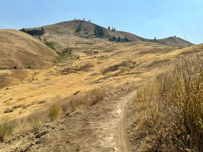
I was the only car at the Horse Lake Trailhead, not particularly surprising given it was a weekday and the temperature was a balmy 99 degrees. I crossed the road to the start of the hike, where the trail immediately splits into two trails. I opted to go left, which I believe is the Canyon Overlook trail, with hopes of getting some nice views of Wenatchee and the Columbia River.
Start of the hike
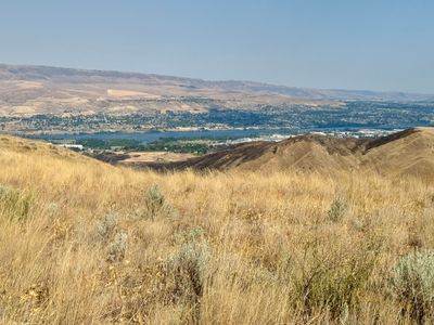
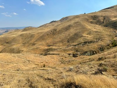
Fortunately, there was a steady breeze as I hiked along the Canyon Outlook trail, making it seem not nearly as hot. After what seemed like 5 minutes hiking on the trail, which was a somewhat narrow and well compacted single track, I reached the ridge and had nice views off Wenatchee and the Columbia River.
First views of Wenatchee
After connecting back up with the Sage Hills trail, the trail began to slowly descend as it wrapped around the canyon. As I walked, there were an insane amount of crickets, or possibly grasshoppers, jumping along the trail, probably spooked by my movement. It wasn't just a small section, it was more or less the entire hike. Having recently had a pretty bad reaction to a hornet sting, I couldn't help but jump myself when they landed on me…
Wrapping around the canyon
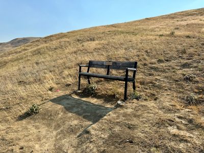
I passed by the Homestead trail and then began to ascend out of the canyon towards another ridge. By this point, even with the nice breeze, I was sweating a ton and slowed my pace a bit. It didn't take much vertical gain to get out of the canyon and soon I crossed another trail, Snake Bite, which had a bench off to the side. Would have been a nice place to stop for a break, but I didn't have time, needing to still go to Fred Meyer and pick up some food for dinner.
Bench near Snakebite trail
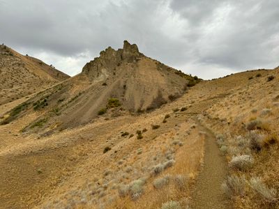
The trail wrapped around into another canyon and after traversing a short distance along the hillside, it started to descend down. I went to the first switchback and decided this would be my turn around point. I was only a mile and a half in, but with triple digit temperatures, this was a good turnaround point for me.
Sage Hill trail descending
I retraced my steps on the way back, but stayed on the Sage Hills trail instead of the canyon overlook trail, with this section of the Sage Hills trail definitely feeling like a mountain biking trail, with a handful of large banked turns.
A short hike, but nice to get out in a new area, as well as find some clear air. Looking forward to exploring the Wenatchee foothills more, especially next spring when the hills are covered in wildflowers.
Comments
on this trip report · Jul 2024
More From The Area
Nearby Trip Reports
beExploring / Wenatchee
Comments
0No comments yet. Be the first to share your thoughts!