Balsamroot Trailhead
720 ft
No restrooms No fee 1 hike
Trails: Balsamroot Trail
View Trailhead →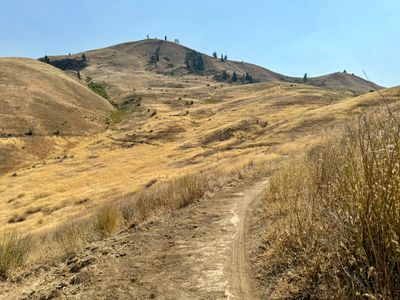
Wenatchee — Washington State
Wildflower hillsides, alpine lakes, basalt viewpoints, and singletrack sagebrush trails — all within 30 minutes of downtown.
All Things to Do →beExploring / Wenatchee
Wenatchee sits at the edge of two landscapes — the sagebrush Columbia Plateau and the eastern Cascades — making it one of the best hiking bases in central Washington. The hikes near Wenatchee range from easy foothill singletrack to high alpine lakes, with most accessible from downtown in under 30 minutes. Wenatchee hiking trails like Sage Hills and Balsamroot are excellent from early spring through fall; alpine routes near Mission Ridge open up in summer and stay good through October.
Use the interactive trail map below to explore hikes and trailheads by location, or browse the directory and conditions before you go.
beExploring / Wenatchee
Browse all 5 hikes accessible by car from Wenatchee. Use the map layers control to toggle between hike pins and trailhead pins, or remove trail lines from view. Click Show on Map to locate a hike, or open the fullscreen map to browse the full list alongside the map.
Best spring wildflower hike
Wenatchee
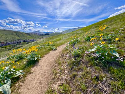
The best spring wildflower hike near Wenatchee. Arrowleaf balsamroot carpets the open sagebrush hillsides above the Columbia River from late April through May, making this one of the most colorful trails in central Washington during peak bloom. At 3.6 miles with 540 feet of gain, the route is approachable for most fitness levels and is typically one of the first trails in the area to open each season.
Best viewpoint hike
Wenatchee
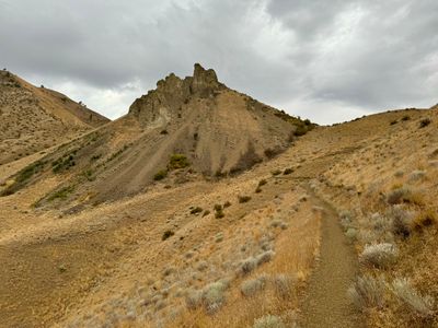
A short but rewarding climb to a dramatic basalt butte in Tumwater Canyon above the Wenatchee River. The 2.3-mile round trip gains 730 feet to a summit with 360-degree views of the Columbia River, Wenatchee Valley, and the surrounding Cascades, one of the best quick viewpoint hikes accessible from the city.
Best alpine hike
Wenatchee
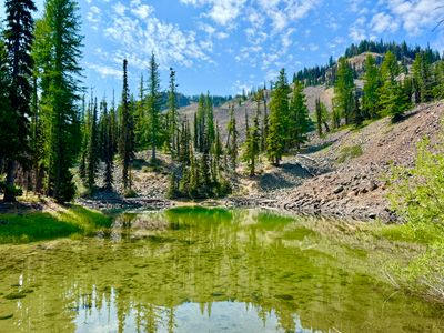
The standout alpine hike accessible from Wenatchee, a steady climb through forest to two mountain lakes beneath Mission Ridge's rocky ridgelines. At 3.2 miles with 980 feet of gain, it's a genuine workout with a satisfying payoff. The upper lake views and rocky terrain give it a high-country feel rare for a sub-4-mile route.
East Wenatchee
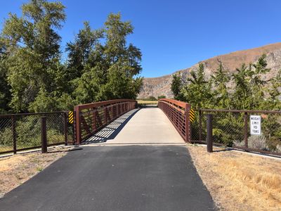
The most direct paved connection between Lincoln Rock State Park and downtown Wenatchee, following the Columbia River past Rocky Reach Dam before tying into the Apple Capital Loop Trail. It's an easy, flat ride or walk that works for all fitness levels, and staying at Lincoln Rock State Park makes it a great excuse for a bike ride into town rather than driving. Just plan around the seasonal gate hours each spring, when the trail near the dam doesn't open until noon.
Best year-round trail
Wenatchee
The best year-round trail network close to Wenatchee, with rolling singletrack through open sagebrush, continuous Columbia River Valley views, and good spring wildflowers. Multiple loop options suit every pace, from short out-and-backs to the full 4.5-mile traverse. Popular with hikers and mountain bikers alike, and one of the driest trails in the area after rain.
beExploring / Wenatchee
Compare Wenatchee-area hikes side by side to find the right trail for your trip.
| Name | Distance | Difficulty | Elevation Gain | High Point | Best Season(s) |
|---|---|---|---|---|---|
| Balsamroot | 3.6 miles, roundtrip | Easy | 540 ft | 1,110 ft | Mar – Jun |
| Castle Rock | 2.3 miles, roundtrip | Moderate | 730 ft | 1,758 ft | Apr – Nov |
| Clara and Marion Lakes | 3.2 miles, roundtrip | Moderate | 980 ft | 5,545 ft | Jun – Oct |
| Rocky Reach Trail | 5.5 miles, one way | Moderate | 187 ft | 740 ft | Year-Round |
| Sage Hills Trail | 4.5 miles, one way | Moderate | 1,300 ft | 1,834 ft | Year-Round |
beExploring / Wenatchee
Most Wenatchee-area trailheads are free with no parking pass. Clara and Marion Lakes near Mission Ridge requires a Northwest Forest Pass. Check the trailhead listings below for current details.
March through May is the best season for foothill trails. Balsamroot and Sage Hills are at their most colorful then. Alpine routes near Mission Ridge usually wait until late June.
Leavenworth is about 25 miles west, Entiat about 20 miles north, and Lake Chelan about an hour. Use the related guides if you want a bigger trail day than the Wenatchee foothills.
beExploring / Wenatchee
Quick weather, air quality, and trail closures for hike planning. Fire restrictions and other details live on the full conditions page.
beExploring / Wenatchee
Browse trailheads in the Wenatchee area by name, parking, and facilities. Trailheads with trip reports link to dedicated pages with hike details and map information.
720 ft
Trails: Balsamroot Trail
View Trailhead →4,233 ft
Trails: Beehive
1,455 ft
Trails: Nahahum Trail
986 ft
Trails: Castle Rock Trail
View Trailhead →1,190 ft
Trails: Day Drive Connector
4,265 ft
Trails: Devil's Spur
1,711 ft
Trails: Horse Lake View Point, Canyon Overlook Trail, Sage Hills Trail
View Trailhead →1,038 ft
Trails: Jacobson Hiking Trail
1,110 ft
Trails: Balsamroot Trail, Maiden lane connector
View Trailhead →2,947 ft
Trails: Stairway to Heaven, Wag More
1,759 ft
Trails: Old Ranch Road Trail
1,022 ft
Trails: Orchard Loop, Orchard Spur
1,084 ft
Trails: Saddle Rock Main Trail, Dry Gulch Main Trail
1,142 ft
Trails: Sage Hills Trail
3,070 ft
Trails: Vulture Gulch, Creature Comfort
4,618 ft
Trails: Squilchuck Trail
View Trailhead →3,138 ft
Trails: PTD, The Meadow Trail, Inconceivable, Wag More
beExploring / Wenatchee
Wenatchee Guide
Overview, seasons, and trip planning
Skiing
Mission Ridge and Marion Lake tours
Weekend Itinerary
Hikes inside a 2–3 day plan
Conditions
Weather, AQI, and trail closures
Things to Do
Skiing, paddling, markets, and more
Leavenworth
Bavarian village 30 minutes west
Lake Chelan
Wine country and hiking 1 hour east
Entiat Hikes
Silver Falls and Entiat Mountains
Leavenworth Hikes
Enchantments, Icicle Gorge, and more
beExploring / Wenatchee