
Snoqualmie Pass — Winter
Snowshoeing at
Snoqualmie Pass
Gold Creek Pond, Commonwealth Basin, Kendall Peak Lakes, and more — winter trails just an hour from Seattle.
beExploring / Snoqualmie Pass
Overview
Snoqualmie Pass offers some of the most accessible snowshoeing in the Washington Cascades — a short drive from Seattle, no lift ticket needed, and routes for every ability level. Easy loops around Gold Creek Pond and along the Palouse to Cascades Trail at Hyak suit families and beginners. Commonwealth Basin, Kendall Peak Lakes, and the Alpental Valley deliver deeper wilderness experiences for those comfortable with more challenging terrain.
beExploring / Snoqualmie Pass
Snowshoeing at a Glance
Best for beginners & families
Gold Creek Pond — short, flat, stunning alpine lake views
Best scenery
Commonwealth Basin / PCT — deep backcountry, Red Mountain backdrop
Most accessible
Hyak Sno-Park — right off I-90, flat Palouse to Cascades Trail
Avalanche terrain
Commonwealth Basin and Alpental Valley — check NWAC before going
beExploring / Snoqualmie Pass
Before You Go
Avalanche Awareness
Commonwealth Basin and the Alpental Valley route to Source Lake both pass through avalanche terrain. Check the Northwest Avalanche Center (NWAC) forecast before heading out on either route.
Sno-Park Permits
Gold Creek Sno-Park requires a standard Sno-Park permit. Hyak Sno-Park requires a standard permit plus a special groomed trails permit. Both are available at outdoor retailers or online at recreation.gov.
Check Trail Conditions
Snow depth and trail coverage vary significantly through the season. Check WTA trip reports or WSDOT webcams before heading up, especially in early December and late March.
beExploring / Snoqualmie Pass
Popular Snowshoe Trails
Gold Creek Sno-Park
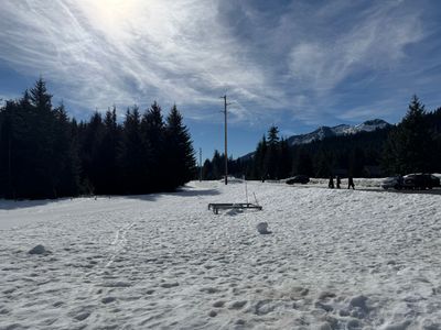
Gold Creek Pond
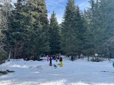
The Gold Creek trail follows a gentle snow-covered road to Gold Creek Pond, a scenic alpine lake surrounded by snow-draped evergreens and rugged peaks. On clear days, Chikamin Peak and the Alpine Lakes Wilderness create a stunning backdrop. The wide, flat trail is ideal for families and newcomers to snowshoeing. More adventurous snowshoers can continue beyond the pond deeper into the valley. The route begins at Gold Creek Sno-Park — take a right on Lake Mardee Road and drive about half a mile to the trailhead sign.
- Gold Creek Sno-Park
- Sno-Park permit required
- Easy — great for families
Pacific Crest Trail
Commonwealth Basin
Snowshoeing along the PCT through Commonwealth Basin offers a beautiful backcountry experience. The route follows the PCT through snow-covered evergreen forests, then descends toward Commonwealth Creek. From there, you can continue up the valley for views of Red Mountain and Lundin Peak, or follow the PCT as it climbs further into the basin. Note that this route enters avalanche terrain — consult the Northwest Avalanche Center for current conditions before going.
- PCT / Commonwealth Basin Trailhead
- Avalanche terrain — check NWAC
- Moderate to Strenuous
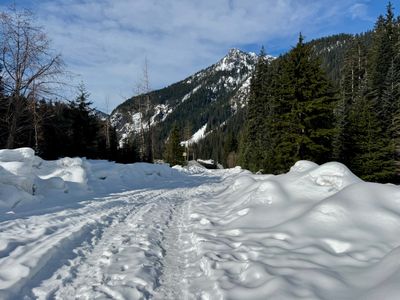
Gold Creek Sno-Park
Kendall Peak Lakes
Three small alpine lakes nestled among forested slopes become a snow-covered retreat in winter. The route primarily follows a closed forest road, making navigation relatively straightforward. On clear days, viewpoints offer sweeping views including Rampart Ridge, Kendall Peak, Granite Mountain, Silver Peak, and even Mount Rainier. Experienced snowshoers can venture off the main trail toward the lakes, but should remain aware of avalanche risks in the area. The route begins at Gold Creek Sno-Park.
- Gold Creek Sno-Park
- Sno-Park permit required
- Moderate — good views
Alpental
Alpental Valley — Source Lake
Source Lake sits at the end of the Alpental Valley, surrounded by Chair, Bryant, and Hemlock peaks — a dramatic setting and a natural turnaround point. Start in the upper Alpental parking lot and take the right fork at the trail split (the left is for backcountry skiers returning). Note that the trail enters avalanche terrain shortly after the start — careful evaluation of conditions is required. As of 2025, parking anywhere at Alpental requires a Summit parking pass.
- Upper Alpental Parking Lot
- Parking pass required
- Avalanche terrain — check NWAC
Hyak Sno-Park
Hyak Sno-Park — Palouse to Cascades Trail
From Hyak Sno-Park, snowshoers can access the groomed Palouse to Cascades State Park Trail — a former railroad route — and head east along the flat track with views of Keechelus Lake and the Gold Creek Valley. The Sno-Park also has a groomed sledding hill and bathroom facilities. This is one of the most accessible beginner-friendly snowshoe routes at the pass, and a good pick for groups that want to combine snowshoeing and sledding. Both a standard Sno-Park permit and a special groomed trail permit are required.
- Exit 54 off I-90
- Sno-Park + groomed trail permit required
- Easy — beginner friendly
Near Denny Creek
Denny Creek Road
Denny Creek Road becomes a snow-covered trail in winter — an easy, accessible option for beginners and those new to snowshoeing. The route winds through towering evergreen forest, following high above Denny Creek as it flows below. One downside: the road parallels I-90, so highway noise is present throughout. There is no dedicated trailhead parking, but parking can be found along Highway 906 east of the I-90 overpass.
- Park along Hwy 906
- No parking fee
- Easy — some highway noise
beExploring / Snoqualmie Pass
Avalanche Forecast
Avalanche forecasts for Snoqualmie Pass are provided by the Northwest Avalanche Center (NWAC) and typically updated at 6pm for the following day. Commonwealth Basin and the Alpental Valley route both enter avalanche terrain — check the forecast before heading into either area.
beExploring / Snoqualmie Pass
Webcams
Use these WSDOT cameras to check snow coverage at the pass before driving up.
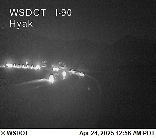
Near Hyak Sno-Park at ~2,500 ft elevation
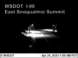
Summit East base area at ~2,600 ft elevation
beExploring / Snoqualmie Pass