Click on an item on the map to view information about it
beExploring · Trip Reports · Washington · Chelan Falls
Cultus Jim & Chelan Bob Loop
A short loop near Chelan Falls with beautiful views of the Columbia River and surprisingly good elevation gain for its size. At low elevation, the trail sheds snow earlier than most options in the area, a good early-s…
Plan This Trip
At a Glance
straighten
Distance
1.6 miles, loop
trending_up
Elevation Gain
500 ft
landscape
High Point
1,194 ft
backpack
Activity
Hike
Best For
WildflowersDogs AllowedDiscover PassClose to TownPhoto Highlights · November 2023
Jump to Trip Report →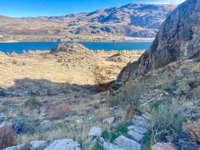
Plan This Trip
Why Go
Perched above the Columbia River, the upper section of Beebe Springs Natural Area in Chelan Falls offers a short loop trail with moderate elevation gain. Sweeping views of the Columbia River are the main attraction, and this is a great shoulder season hike, with wildflowers in the spring, while the yellow leaves of the fall contrast nicely with the blue of the river in the fall. Note, both trails navigate a steep hillside, and this hike is not recommended during the winter when the trail may be icy.
There are two trailheads that access this loop, the Toad Creek trailhead in the Chelan Fish hatchery at the bottom of the loop and the upper trailhead off of Route 150 heading towards Chelan at the top of the loop. Either trailhead is fine, and which you choose will likely depend on where you are coming from.
From the Toad Creek trailhead, follow the Toad Creek Trail until it splits into a loop and head left. In a short distance take a left at the intersection with the Chelan Bob and follow the trail up the steep hillside, admiring views of the Columbia River. Towards the top, you will pass by signage detailing the local geology. Depending on the season, the trail may be a little hard to follow at the top, but you will eventually crest a hill and descend down towards the upper parking lot. From the parking lot, head north along a dirt road and the Cultus Jim trail will be on your right. Descend the steep hillside, and after crossing the Toad Creek bridge, head left on the Toad Creek loop trail.
Placeholder in dev for ad
Plan This Trip
Route & Map
Plan This Trip
Getting There
directions_car
Directions
Heading north on Highway 97 from Wenatchee, just after crossing the Beebe Bridge, take a left onto Route 150. Cross the railroad tracks and then take a right onto Beebe Fish Hatchery Road, and continue along the road for a short distance until you enter the parking lot. If you are coming from the Lake Chelan area, the upper parking lot is closer. Take Route 150 from Chelan, and after passing by Chelan Fruit on your left will be a small parking area.
local_parking
Parking
Both the Toad Creek trailhead and the upper parking lot require a Discovery Pass, as the Beebe Springs Natural Area is part of the Washington State Parks system. These trails typically don't see a lot of visitors, and finding a parking spot will not be an issue.
edit_note
Field Notes · Personal Trip Report
Autumn Breakthrough
I chased an afternoon sun break above the Columbia River and discovered why locals keep this steep loop to themselves.
calendar_today November 11, 2023
straighten 1.3 miles, loop · 480 ft gain
chat 0 comments
With the upper regions of the Chelan Valley coated in an early season snow, Beebe Springs Natural Area was the perfect place to take advantage of an afternoon sun break. While I had explored the river trails, I had yet to hike the upper section and was looking forward to a quick hike with outstanding views of the Columbia River.
I pulled into an empty parking lot, which wasn't surprising given its well past tourist season in Lake Chelan, and even during tourist season, I don't think these trails get a ton of use. While the rain had dissipated and the sun was out, it was still quite windy, and I threw on my wind breaker for some added protection.
For no real particular reason, I decided to head Cultus Jim for the descent. I walked a short ways up a dirt road and then took a right onto the trail and began my descent down the steep hillside. The trail is a mixture of switchbacks and stone stairs, and given the fast approaching winter, I noted this would not be a good hike when there is snow on the ground! But it wasn't that cold yet, and I enjoyed the views as I made my way down the trail.
Heading down Cultus Jim trail
It was a pretty quick hike down to the flats, and soon I found myself crossing the Toad Creek Bridge. Shortly thereafter at the intersection with the Toad Creek loop trail, and headed right on the loop towards the Chelan Bob trail.
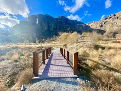
Toad Creek Bridge
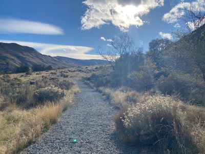
The Toad Creek trail is a wide gravel trail, and this section meadered slightly up the hillside. Even with the steady wind, I could hear the drone of traffic on highway 97 and route 150 as I worked my way towards Chelan Bob.
Toad Creek Loop trail
The intersection with Chelan Bob trail was well marked, and I started my ascent up the trail. For some reason, the views from Chelan Bob seemed better than Cultus Jim. Perhaps the views were more sweeping, or the numerous yellow trees made a nice contrast with the river? I found myself hopping up on rock outcrops as I progressed up the trail to enjoy the view and snap some photos.
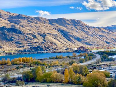
Beebe Bridge and the Columbia River
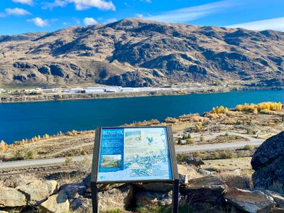
Three quarters of the way up the Chelan Bob trail there were a couple of interpretive signs with interesting information about the history and geology of the area.
Interpretive Sign on Chelan Bob trail
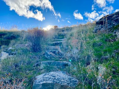
Near the very top, it was a little hard to follow the trail. The sage brush and grass obscured the trail near the last interpretive sign, and it took a small amount of investigation to locate the trail and stone steps. There also seemed to be a couple other faint side trails, either from the deer or perhaps people venturing off the trail.
Chelan Bob trail
I followed the stone steps onto the top of the rock outcropping above the parking lot and then made my way down to the car. It was a nice short hike, and great to get out and enjoy the late fall sunshine. Winter is almost here!
Comments
on this trip report · Nov 2023
beExploring / Lake Chelan
Comments
0No comments yet. Be the first to share your thoughts!