
Winthrop — Backcountry Skiing
Backcountry Skiing
near Winthrop
Delancey Ridge, Powder Cache, Blue Lake, and Maple Pass — Highway 20 tours, Washington Pass conditions, and avalanche resources.
beExploring / Winthrop
Overview
The terrain above Highway 20 near Washington and Rainy Passes is some of the most accessible and rewarding backcountry skiing on the eastern slopes of the North Cascades. Delancey Ridge, Powder Cache, and Blue Lake all sit within reach of the highway when the gate is open, offering significant vertical in north-facing terrain that holds cold snow well after storms. Maple Pass is the classic spring objective once the road opens in late April.
Highway 20 access is the defining variable for most tours here. Gate locations shift year to year, and the difference between a gate at Silver Star versus Early Winters is the difference between a practical day tour and an expedition. Check WSDOT and the NWAC East Slopes North forecast before every trip.
beExploring / Winthrop
Backcountry at a Glance
Best winter storm tour
Powder Cache — north-facing slopes above Highway 20, accessible when the gate is open past Early Winters
Best steep objective
Delancey Ridge — 3,000+ vertical feet of fall-line skiing from the Silver Star Sno-Park
Best spring tour
Maple Pass — moderate terrain with big views, ideal on a corn snow cycle after Highway 20 opens
Best early-season access
Blue Lake — trailhead sits right off Highway 20 before the full winter closure, good for early-season powder
Always check first
NWAC East Slopes North forecast and current Highway 20 gate location before driving up
beExploring / Winthrop
Before You Go
Highway 20 Access
All the major objectives near Washington and Rainy Passes depend on Highway 20, which closes mid-November through mid-April. Gate locations vary year to year — when the gate is at Silver Star, access is much better than when it is held at Early Winters. Check WSDOT before every trip.
Avalanche Terrain
Every meaningful objective in this guide involves avalanche terrain. The NWAC East Slopes North zone forecast is updated daily and should be treated as mandatory reading before any tour in the Washington Pass area.
Sno-Park Permits
The Silver Star Sno-Park (Delancey Ridge access) requires a Washington State Sno-Park permit. The Powder Cache pullout along Highway 20 has no fee. Permits are available at outdoor retailers and online through the Washington State Parks website.
beExploring / Winthrop
Ski Tours
Silver Star Sno-Park — Mazama
Delancey Ridge
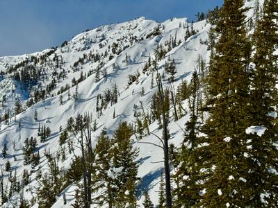
Delancey Ridge offers more than 3,000 vertical feet of sustained fall-line skiing, making it one of the standout backcountry objectives in the North Cascades when conditions are right. The terrain is relatively steep and committing — solid avalanche stability is essential before committing to the descent. A predominantly southern exposure means snow quality can shift quickly after clear days, so timing the tour around fresh storm snow or cold overnight freezes is key. Access is straightforward when Highway 20 is plowed to the Silver Star Gate. If the gate is only open to Early Winters, the approach becomes significantly longer without sled support.
Statistics
- Length: 4 miles, roundtrip
- Elevation Gain: 3,600 ft
- High Point: 6,800 ft
Highway 20 Pullout — Mazama
Powder Cache
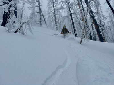
Just west of Varden Creek, the north-facing slopes above Highway 20 — locally known as the Powder Cache — are a reliable storm skiing destination when conditions line up. The north aspect preserves cold snow well after storms and the forested terrain offers well-spaced trees through a wide vertical range. Access requires Highway 20 to be open past the Early Winters gate, and the pullout along the highway serves as the staging area with no parking fee. This is not a terrain trap for the inexperienced — the upper slopes are steep and avalanche evaluation is critical — but on the right day it skis as well as anything in the North Cascades.
Statistics
- Length: 5 miles
- Elevation Gain: 4,000 ft
- High Point: 6,986 ft
Blue Lake Trailhead — Washington Pass
Blue Lake
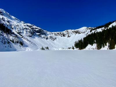
Blue Lake sits just outside the North Cascades National Park boundary and is one of the more versatile ski touring destinations along Highway 20. The lake itself is a popular objective, with mellow touring around the basin and access to bigger lines on the surrounding slopes. In late fall before the full highway closure sets in, the trailhead is an excellent launching point for early-season powder days at high elevation. When more snow fills in, experienced skiers can reach Spire Gully and other technical objectives above the lake. Highway 20 access is required — the road closes seasonally — and conditions at elevation can change quickly.
Statistics
- Length: 5 miles, round trip
- Elevation Gain: 2,000 ft
- High Point: 7,300 ft
Rainy Pass — Highway 20
Maple Pass
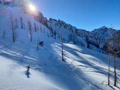
Maple Pass is a classic North Cascades spring ski tour, known for its approachable terrain, big views over Lake Ann, and reliably good corn snow conditions once Highway 20 opens in late April or early May. The route climbs steadily from Rainy Pass to the high ridge connecting Heather Pass and Maple Pass, where the terrain opens to broad, rolling slopes well-suited to intermediate backcountry skiers. This is primarily a spring objective — attempting it in midwinter requires either sled access along the closed highway or a very long approach on skis. In a good corn cycle it is one of the most enjoyable moderate tours in the range.
Statistics
- Length: 5 miles, roundtrip
- Elevation Gain: 1,900 ft
- High Point: 6,600 ft
Twisp River Fun Ranch
Twisp River Valley
Short runs through well-spaced glades in the Twisp River Valley make this a fun and accessible valley tour on a day when Highway 20 access is not an option. The terrain is low-angle by backcountry standards, with good tree spacing and a forgiving approach from the valley floor. This is not a tour you would build a trip around, but as a local powder day alternative when bigger objectives are out of reach or conditions are uncertain, it delivers easy turns in a scenic river setting. No parking fee is required and the approach is accessible from Highway 153 regardless of Highway 20 status.
Statistics
- Length: 5.1 miles, round trip
- Elevation Gain: 2,050 ft
- High Point: 3,000 ft
beExploring / Winthrop
Conditions
Observed conditions over the past several days are taken from two NWAC telemetry stations at Washington Pass. Temperature and precipitation are from the Washington Pass Base Station at 5,450 ft; wind data is from the Washington Pass Upper station at 6,680 ft. Forecasted weather uses the NWS grid point OTX/44,148 at approximately 4,320 ft near Washington Pass.
beExploring / Winthrop
Avalanche Forecast
Avalanche forecasts for the Winthrop and Washington Pass area are provided by the Northwest Avalanche Center (NWAC) under the East Slopes North zone. Forecasts are typically updated at 7am for the current day. Check the full forecast at nwac.us before any backcountry tour.
beExploring / Winthrop
Plan Your Trip
beExploring / Winthrop