
Stehekin — Things to Do
Rainbow Falls
A 312-foot waterfall pouring out of a hanging valley, 3.4 miles up the road from Stehekin Landing and a five-minute walk from the car.
All Things to Do →beExploring / Stehekin
Overview
Rainbow Falls is the most visited natural feature in Stehekin, and the reason is simple arithmetic: 312 feet of waterfall at the end of a 0.4-mile gravel path. Ice age glaciers carved the U-shaped troughs that form both the Rainbow Creek and Stehekin River valleys, but the smaller glacier in the creek valley did not cut as deep. That left Rainbow Creek suspended high above the river valley, and the water has been falling off the edge of that hanging valley ever since.
The falls sit 3.4 miles up Stehekin Valley Road from the landing, on the shuttle circuit and on the bus tour that the day boats connect with. That combination puts a genuinely big waterfall within reach of visitors who only have a few hours on shore, which is rare in the North Cascades. Almost everything else worth seeing out here asks for a full day or a permit.
Because Stehekin has no road connection to the outside world, a visit to Rainbow Falls is never a standalone stop. It is something you fit into a ferry day trip or a longer stay, alongside the Pastry Company, the Buckner Orchard, and the trails that climb from the valley floor into North Cascades National Park.
beExploring / Stehekin
What to Expect
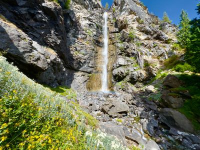
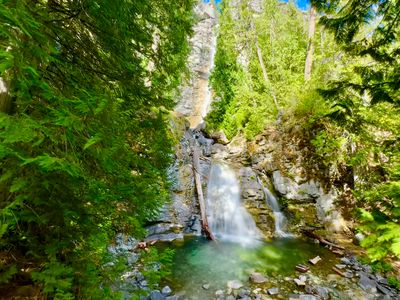
Top: the upper viewpoint. Bottom: the lower cascade from the base of the falls.
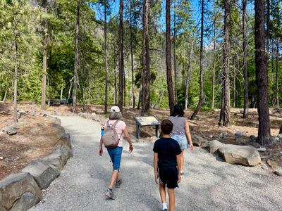
The gravel path at the start of the trail, near the picnic bench.
Getting There
From Stehekin Landing, follow Stehekin Valley Road 3.4 miles upriver, then turn right onto Rainbow Falls Road and continue a couple hundred yards to where the road ends at the trailhead. There are no rental cars in Stehekin, so in practice that means biking, taking the shuttle bus, riding the ferry bus tour, or walking. A separate trail also comes in from the road, which is where the bus drops passengers.
The Trail
Roughly 0.4 miles round trip with about 120 feet of gain on gravel. A couple hundred yards in, the trail splits. Right drops to the base of the falls and the lower cascade. Left climbs to the upper viewing area on a short loop, where going right takes a series of steps up a steeper slope and going left follows a more gradual grade. Doing the upper section as a loop, up the steps and down the gentle side, is the easiest way to handle it.
The Viewpoints
The lower viewpoint gives you the bottom cascade up close, with the rest of the falls visible above but partly obscured. The upper viewpoint is the better one: the forest opens up and you get the full drop through the gorge. Wildflowers often persist late in the season along the upper trail, fed by the mist off the pool below.
Parking & Facilities
A small free lot sits at the end of Rainbow Falls Road, with no fee or pass required and rarely any competition for a spot. There is a vault toilet at the trailhead and a picnic bench a short way along the trail, which is the obvious place to eat whatever you picked up at the Pastry Company. No water, no garbage service, no cell coverage.
Flow & Timing
The falls run year-round on glacial melt, but the volume swings hard through the season. May through early July is when the creek is loudest and the spray reaches the viewpoints. By August the flow is visibly lower and the falls read more as a tall ribbon than a torrent, which is easier for photos and less pleasant for anyone hoping to get soaked. Fall brings quiet and color, limited mainly by the thinning ferry schedule.
Crowds
Rainbow Falls is the busiest spot in Stehekin, but "busiest" is relative in a place with no road access. Traffic arrives in waves tied to the shuttle and the day boat bus tour. Show up between those waves, or early, and there is a real chance you will have the falls entirely to yourself.
beExploring / Stehekin
Tips for Visiting
You cannot drive here. Every visit starts with a ferry, float plane, helicopter, or multi-day backpack into Stehekin, so the falls are always part of a bigger trip.
May through early July is peak flow. By August the falls are still worth the walk but the volume drops noticeably and the spray mostly disappears.
Renting a bike at the landing is the most flexible way to reach the trailhead. It removes any dependence on shuttle timing, which matters a lot if you are on a day boat.
At the upper loop, go right for the steps and left for the gentler grade. Doing it as a loop means you only climb the steep side once.
There is a picnic bench at the start of the trail. Stehekin Pastry Company is on the same stretch of valley road, which makes for an easy pairing.
Arriving before the first shuttle load gets you the falls to yourself. Outside the bus tour windows the trailhead is often empty.
beExploring / Stehekin
Explore Stehekin
More guides for the head of Lake Chelan and the North Cascades.
beExploring / Stehekin