Click on an item on the map to view information about it
beExploring · Trip Reports · Washington · Manson
Safety Harbor Creek
A surprisingly flat backcountry trail in a remote creek drainage with waterfalls and wildflowers. At only 200 feet of elevation gain, Safety Harbor Creek delivers remote wilderness without a punishing climb. A hidden …
Plan This Trip
At a Glance
straighten
Distance
6.4 miles, roundtrip
trending_up
Elevation Gain
200 ft
landscape
High Point
4,500 ft
backpack
Activity
Hike
Best For
WildflowersDogs AllowedNo Pass RequiredRiverLake ViewsWaterfallRemotePhoto Highlights · September 2025
Jump to Trip Report →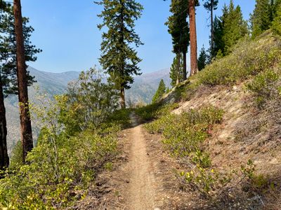
Plan This Trip
Why Go
The Safety Harbor Creek trail is a 4.6 mile trail located on the north shore of Lake Chelan. It requires over 20 miles of forest service roads to the Safety Harbor Creek trailhead, and therefore is more popular with dirt bikes than hikers. However, it's an enjoyable trail, with the first three miles contouring around the western side of Nelson Butte with minimal elevation gain. The trail goes through a mix of forest, more open areas and a couple of cliff bands, with occasional views of Lake Chelan along the way. At 3.1 miles, it intersects with the Uno Peak trail next to Safety Harbor Creek. You can veer slights off the trail towards the creek to find a shaded spot along the creek next to an old dam, which makes a good turnaround spot. Or continue hiking up the trail along Safety Harbor Creek for 1.5 more miles until the intersection with the Summit trail. Safety Harbor Creek trailhead is typically accessible in mid to late May after the snow melts along the road, and you will find many wildflowers in the spring, including the beautiful Tweedy's lewisia. The Safety Harbor Creek trail can also be accessed from the Chelan Summit Trailhead by following the Summit trail for a little under two miles.
Placeholder in dev for ad
Plan This Trip
Route & Map
Plan This Trip
Getting There
directions_car
Directions
Proceed to the Antilon Lake Sno-Park and continue on Grade Creek Forest Service Road 8200 for 18.6 miles. Turn left onto Safety Harbor Trailhead Forest Service 8200-155 Rd and proceed for 1.2 miles to reach the trailhead. As of 2025, the Grade Creek Forest Service Road is in pretty good condition, with work being done on the road in 2024 to allow large machinery access for fire preparation on the Pioneer Fire. However, it is best to check with the Chelan Ranger District for the latest road conditions.
local_parking
Parking
There is a good sized parking lot at the The Safety Harbor Creek trailhead and no parking passes or fees are required. There is a pit toilet tucked away in the woods next to the trailhead.
edit_note
Field Notes · Personal Trip Report
Nelson Butte Cliff Ramble
I discovered the lower Safety Harbor Creek section's hidden cliff bands and creek crossings made for a surprisingly rewarding family-friendly hike despite modest elevation gain.
calendar_today September 13, 2025
straighten 6.6 miles, roundtrip · 220 ft gain
chat 0 comments
When I first noticed the Safety Harbor Creek trail on a map, I didn't think it would make for a very good hike. However, on my loop hike around Uno Peak, the upper section of Safety Harbor Creek trail that follows the creek up was really nice, and I had noticed the lower section of the trail cutting through some cliffs on the side of Nelson Butte on my way down the Uno Peak trail. After looking at the map again, I figured it could be a good hike for the family, given the low elevation gain.
We set out from the Safety Harbor Creek trailhead, and I had set expectations low - wasn't sure if we would have any good views, and warned my family that the trail could be in rough shape. Although the upper section of the trail was in reasonable shape when I did the Uno Peak loop, parts of the Uno Peak trail were very overgrown and I wasn't sure what to expect on this section of the Safety Harbor Creek. To our pleasant surprise, the trail was in very good shape, and there was only a couple of small sections that were a little overgrown.
Beginning section of the trail
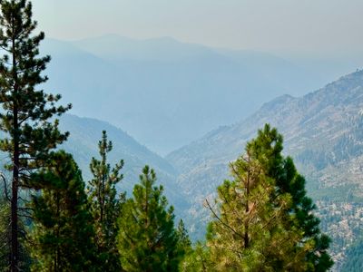
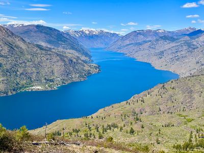
There were certainly some decent views from the trail, however the smoke obstructed the views towards the lake. While we were able to just barely make out the lake near Safety Harbor, it's hard to tell in the photo. Fortunately the smoke wasn't too bad, it was only when looking over long distances that it became very apparent. I had half considered abandoning the hike because of the smoke, but was glad I didn't.
Smoke obscured view of Lake Chelan
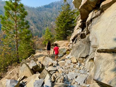
A little over two miles into the hike we passed through some cliff bands, with the trail blasted through the rocks. It looks like this may have actually been a road at some point, which made sense once we got to Safety Harbor Creek and noticed an old dam with rebar and concrete on the creek. The trail passes through some steep terrain and it seems an odd place to build a random trail. A little internet sleuthing after the fact indicates there was an irrigation flume from Safety Harbor back towards Manson, so I'm guessing it used to be on this trail. We did see some random boards along the trail and wondered how they got there.
Trail passing through a cliff band
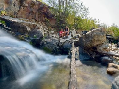
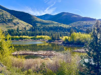
The rest of the hike to the junction with Uno Peak trail was straightforward. There was one downed tree along the trail, otherwise the trail is in great shape. Once at the junction, I asked my wife and son if they wanted to hike up the trail a bit. On my Uno Peak loop, there had been a small canyon where you could sit on some rocks above the creek, however I couldn't remember how far up it was. We opted to just head over by the creek at the junction. We followed what looked like a continuation of the road to the creek, and sure enough there were the remnants of an old dam, with some water coming out an old pipe. There was some shade and it actually made a great spot to hang out, have lunch and hydrate, before heading back.
Break spot on Safety Harbor Creek
The hike back was uneventful. A pair of dirt bikers passed us by on the way to Safety Harbor Creek trailhead. I assume they had come in via the Chelan Summit Trailhead and Summit Trail. Otherwise, we didn't see anyone else on the trail. It's a great moderate hike, and without the smoke there would have been some nice views. If it wasn't for the long drive on forest service roads, it certainly would be a hike I would do more often.
Comments
on this trip report · Sep 2025
More From The Area
Nearby Trip Reports
beExploring / Lake Chelan
Comments
0No comments yet. Be the first to share your thoughts!