Washington State — Hiking
Best Larch Hikes
in Washington State
Where the alpine larches turn gold every October, and how to time a trip around a season that lasts about three weeks.
Washington State Guide →beExploring / Washington State
Overview
Alpine larch is the only conifer in the Cascades that drops its needles, and for roughly three weeks from late September the high country east of the crest turns gold. The trees grow above about 5,500 feet, almost entirely on the dry eastern side, which is why nearly every hike on this list sits east of the Cascade crest even though the drive usually starts west of it.
These eleven trails are the ones we have walked, plus Maple Pass Loop, which is the most photographed larch hike in the state and belongs on any honest list. They run from a 2.8-mile interpretive loop at Blewett Pass to a 15-mile summit day above Lake Chelan, and Colchuck Lake has a full guide of its own covering permits and the boulder field. For a single destination rather than a statewide shortlist, start with the Winthrop hiking guide for the Highway 20 trails or the Lake Chelan hiking guide for the Chelan backcountry.
One thing worth saying plainly: most of the photos below were taken outside larch season. Where a card shows a green summer hillside, the copy says so. Timing, not photography, is what this page is for.
beExploring / Washington State
Where to find golden larches, easiest first
11 trails into larch country, ordered from a family interpretive loop to a 15-mile summit day. Open any card for the full trip report.
Easiest larch hike on Highway 20
Cutthroat Lake
Winthrop
Why Go
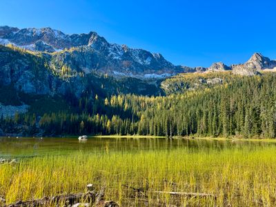
The most accessible larch hike in the North Cascades: 4 miles round trip and 500 feet of gain to a turquoise lake under rocky peaks, with larch stands around the basin. Gentle enough for kids and grandparents, which is rare in larch country. Northwest Forest Pass. The trailhead fills early on October weekends.
Statistics
- Length: 4 miles, roundtrip
- Elevation Gain: 500 ft
- High Point: 4,950 ft
- Difficulty: Easy
- Best Season(s): Jun – Oct
Best short hike near Washington Pass
Blue Lake
Winthrop
Why Go
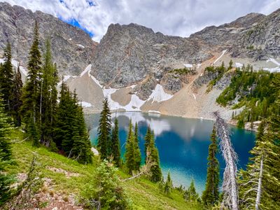
A 4.5-mile round trip and 1,100 feet of gain to turquoise water below Liberty Bell and the Early Winters Spires, with larches scattered through the upper basin. Our photo here is from July, so the hillsides are green; the same slopes turn gold in early October. Northwest Forest Pass.
Statistics
- Length: 4.5 miles, round trip
- Elevation Gain: 1,100 ft
- High Point: 6,260 ft
- Difficulty: Moderate
- Best Season(s): Jul – Oct
Family loop at Blewett Pass
Swauk Discovery Trail
Blewett Pass
Why Go
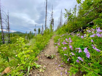
The easy option, and the one furthest south. A 2.8-mile interpretive loop at Blewett Pass with 530 feet of gain, numbered markers and a brochure that explains the forest you are walking through. Larches sit on the slopes around the pass. Our photo is from June. Northwest Forest Pass, and there is a pit toilet at the lot.
Statistics
- Length: 2.8 miles, loop
- Elevation Gain: 530 ft
- High Point: 4,525 ft
- Difficulty: Moderate
- Best Season(s): Jun – Oct
Closest larches to Wenatchee
Clara and Marion Lakes
Wenatchee
Why Go
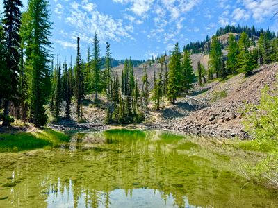
The closest larch hiking to Wenatchee: 3.2 miles and 980 feet of gain to two lakes under the Mission Ridge ridgelines. Short enough for an afternoon, high enough to catch the turn. Photographed in July, so the frame is green. Northwest Forest Pass.
Statistics
- Length: 3.2 miles, roundtrip
- Elevation Gain: 980 ft
- High Point: 5,545 ft
- Difficulty: Moderate
- Best Season(s): Jun – Oct
Big summit, short climb
Stormy Mountain
Chelan
Why Go
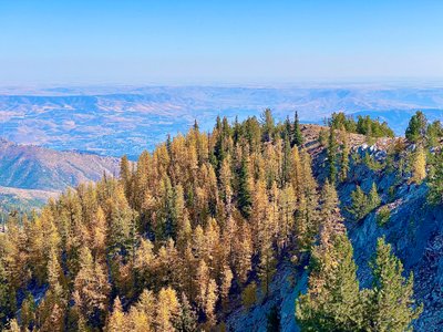
A 3.6-mile round trip to a 7,198-foot summit, one of the best effort-to-payoff trades in the Chelan backcountry. The larches sit on the northern side of the mountain and are on full display from the top. Shot in early October, so this photo is the real thing. No pass, but the drive up Slide Ridge Road is long.
Statistics
- Length: 3.6 miles, roundtrip
- Elevation Gain: 1,201 ft
- High Point: 7,198 ft
- Difficulty: Moderate
- Best Season(s): Jul – Oct
The famous one, and the busiest
Colchuck Lake
Leavenworth
Why Go
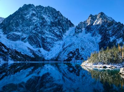
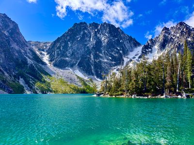
The best known larch hike in Washington and the busiest: 8.2 miles and 2,360 feet of gain to glacial blue water under Colchuck and Dragontail. Larches ring the far shore, which is the view at the top of this page. No permit is needed for a day hike, but a Northwest Forest Pass is, and the lot overflows well before sunrise in October.
Statistics
- Length: 8.2 miles, roundtrip
- Elevation Gain: 2,360 ft
- High Point: 5,614 ft
- Difficulty: Hard
- Best Season(s): Jul – Oct
Larches high above the pass
Twisp Pass
Twisp
Why Go
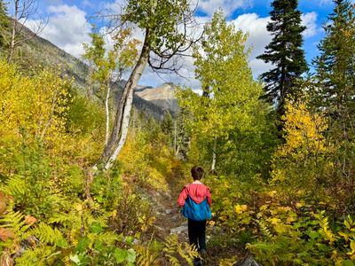
An honest shoulder-season pick rather than a peak-color destination. On our early October visit the larches were only starting to turn, high above the pass rather than along the trail. 8.6 miles and 2,400 feet of gain to the Pasayten boundary, quiet compared with anything on Highway 20. Northwest Forest Pass.
Statistics
- Length: 8.6 miles, roundtrip
- Elevation Gain: 2,400 ft
- High Point: 6,064 ft
- Difficulty: Hard
- Best Season(s): Jul – Oct
Long ridge day above Lake Chelan
Angle Peak Loop
Chelan
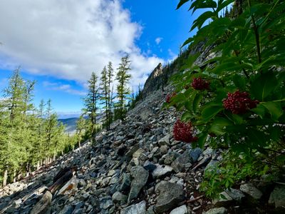
Why Go
An 11-mile loop and 2,600 feet of gain on the ridge above Lake Chelan, with larch stands near the scree fields and views into both the Chelan and Entiat valleys. A long drive to a remote trailhead. Our visit was in August, so the photo is summer green. No pass required.
Statistics
- Length: 11 miles, loop
- Elevation Gain: 2,600 ft
- High Point: 6,890 ft
- Difficulty: Strenuous
- Best Season(s): Jul – Oct
Highest summit on this list
Uno Peak
Manson
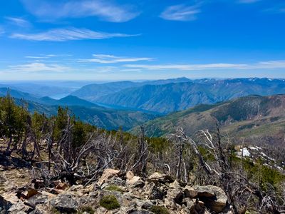
Why Go
The highest summit here at 7,644 feet, reached by a 15-mile loop with 4,600 feet of gain through river drainages, wildflower meadows and larch forest. A full day and then some. Photographed in June, well before the turn. No pass required.
Statistics
- Length: 15 miles, loop
- Elevation Gain: 4,600 ft
- High Point: 7,644 ft
- Difficulty: Strenuous
- Best Season(s): Jul – Oct
The hardest day here
Devil's Backbone
Chelan
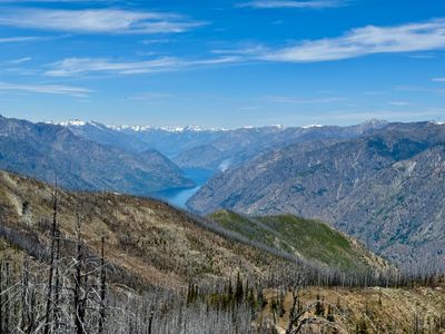
Why Go
The hardest day on this list: 11.8 miles one way and 3,560 feet of gain along a demanding ridge traverse above Lake Chelan, with an outstanding larch display in fall. Our photo is from June. For strong hikers who want the color without the crowds. No pass required.
Statistics
- Length: 11.8 miles, one way
- Elevation Gain: 3,560 ft
- High Point: 7,150 ft
- Difficulty: Strenuous
- Best Season(s): Jul – Oct
The most photographed larch hike in Washington
Maple Pass Loop
Why Go
The larch hike most people picture when they picture larches: a 7.2-mile circuit past Lake Ann to a high ridge linking Maple Pass and Heather Pass, with gold on every slope in early October. At 2,100 feet of gain it is a full workout but within reach of most day hikers. We have not hiked it yet, so there is no trip report and no photo here. The Rainy Pass trailhead is about 52 miles west of Winthrop on Highway 20 and it fills before dawn on fall weekends. Northwest Forest Pass.
Statistics
- Length: 7.2 miles, loop
- Elevation Gain: 2,100 ft
- High Point: 6,870 ft
- Difficulty: Moderate
- Best Season(s): Jul – Oct
beExploring / Washington State
Larch Hike Comparison
Compare distance, elevation and season to match a larch hike to the day you actually have.
| Name | Distance | Difficulty | Elevation Gain | High Point | Best Season(s) |
|---|---|---|---|---|---|
| Cutthroat Lake | 4 miles, roundtrip | Easy | 500 ft | 4,950 ft | Jun – Oct |
| Blue Lake | 4.5 miles, round trip | Moderate | 1,100 ft | 6,260 ft | Jul – Oct |
| Swauk Discovery Trail | 2.8 miles, loop | Moderate | 530 ft | 4,525 ft | Jun – Oct |
| Clara and Marion Lakes | 3.2 miles, roundtrip | Moderate | 980 ft | 5,545 ft | Jun – Oct |
| Stormy Mountain | 3.6 miles, roundtrip | Moderate | 1,201 ft | 7,198 ft | Jul – Oct |
| Colchuck Lake | 8.2 miles, roundtrip | Hard | 2,360 ft | 5,614 ft | Jul – Oct |
| Twisp Pass | 8.6 miles, roundtrip | Hard | 2,400 ft | 6,064 ft | Jul – Oct |
| Angle Peak Loop | 11 miles, loop | Strenuous | 2,600 ft | 6,890 ft | Jul – Oct |
| Uno Peak | 15 miles, loop | Strenuous | 4,600 ft | 7,644 ft | Jul – Oct |
| Devil's Backbone | 11.8 miles, one way | Strenuous | 3,560 ft | 7,150 ft | Jul – Oct |
| Maple Pass Loop | 7.2 miles, loop | Moderate | 2,100 ft | 6,870 ft | Jul – Oct |
beExploring / Washington State
Before You Go
When the Larches Turn
Peak color usually runs from the last week of September through mid October, and it shifts a week either way depending on the summer and the first cold nights. Higher trails turn first. A hard wind or an early snow can strip the needles in a couple of days, so check recent Washington Trails Association reports in the days before you drive.
Arrive Early or Skip the Weekend
Colchuck Lake, Maple Pass and Cutthroat Lake are the three busiest larch trailheads in the state, and all three fill by 8 or 9 a.m. on peak October weekends. Colchuck often fills before sunrise. A Tuesday in the first week of October is a completely different experience from the Saturday beside it.
Highway 20 Closes in November
The North Cascades Highway shuts for the winter, typically in mid November, and does not reopen until mid April. That closure cuts off Rainy Pass, Washington Pass and the Cutthroat trailhead entirely, so Cutthroat Lake, Blue Lake and Maple Pass all end their season with it. Check WSDOT before a late-season trip.
Passes and Roads
Cutthroat, Blue Lake, Twisp Pass, Colchuck, Clara and Marion, Swauk and Maple Pass all need a Northwest Forest Pass or an America the Beautiful pass. The Chelan backcountry hikes, Stormy Mountain, Angle Peak and Devils Backbone, need no pass but require long drives on rough forest roads. Uno Peak is the same.
About the Photos on This Page
Only Cutthroat Lake, Stormy Mountain and Twisp Pass were photographed in October. The rest were hiked in summer, so their cards show green hillsides on trails that turn gold. Each description says which is which. We are filling these gaps as we get back out there in larch season.
beExploring / Washington State
Plan the Rest of the Trip
Every hike here sits in a destination with lodging, food and conditions.
Winthrop Hiking
Highway 20 trails: Cutthroat, Blue Lake, Maple Pass
Lake Chelan Hiking
Stormy Mountain, Angle Peak, Uno Peak and the backcountry
Colchuck Lake
Full guide to the trail, permits and the boulder field
Leavenworth
Base for Colchuck Lake and the Icicle Creek valley
Twisp
Twisp River valley and the quieter Methow trailheads
Washington Conditions
Air quality and weather by destination
Washington State Guide
Every destination we cover, season by season
beExploring / Washington State